
Osaka Prefecture topographic map
Click on the map to display elevation.
About this map
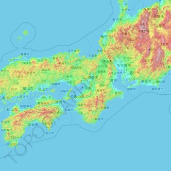
Name: Osaka Prefecture topographic map, elevation, terrain.
Location: Osaka Prefecture, Japan (32.01988 132.89036 37.21988 138.09036)
Average elevation: 188 m
Minimum elevation: -5 m
Maximum elevation: 3,053 m
Other topographic maps
Click on a map to view its topography, its elevation and its terrain.
Shinano River
The Chikuma River originates in the Japanese Alps at altitudes of above 2,000 metres (6,600 ft) and has a basin in its own right of 7,163 square kilometres (2,766 sq mi). The Chikuma continues generally north-northeast joining with the Sai and changing name to the Shinano, after 214 kilometres (133 mi). The…
Average elevation: 565 m
Kanto
The surface geology of the Kantō Plain is the Quaternary alluvium and diluvium. The low mountain vegetation at an altitude of about 500 to 900 m in and around the plain is an evergreen broad-leaved forest zone. The distribution height range of laurel forests is 900 m in Hakone, about 800 m in Tanzawa and…
Average elevation: 29 m
Kochi Prefecture
Kōchi Prefecture comprises the southwestern part of the island of Shikoku, facing the Pacific Ocean. It is bordered by Ehime to the north-west and Tokushima to the north-east. It is the largest but least populous of Shikoku's four prefectures. Most of the province is mountainous, and in only a few areas such…
Average elevation: 155 m
Yamagata Prefecture
The climate of Yamagata Prefecture is characterized by long, hot, and humid summers and long, snowy winters. Both spring and autumn are short, the former often cold, the latter often warm, but both quite dry and sunny. Yamagata Prefecture, along with northern parts of Miyagi and Iwate are the transition areas…
Average elevation: 222 m
Funabashi
Funabashi is located in northwestern Chiba Prefecture approximately 20 kilometers in either direction from the prefectural capital at Chiba and downtown Tokyo. The central area forms a flat diluvial upland of the Shimōsa Plateau. The city sits at an elevation of 20 to 30 meters above sea level, and is…
Average elevation: 17 m
Otaru
Otaru is a port town on the coast of the Sea of Japan in northern Shiribeshi Subprefecture. The southern portion of the city is characterized by the steep slopes of various mountains (notably Tenguyama), where the altitude of the land sharply drops from the mountains to the sea. The land available between the…
Average elevation: 79 m
Suita
Suita is located in northern Osaka Prefecture. The northern part of the city is occupied by the gently sloping Senri Hills, and the southern part is a plain made up of the Yodo River, Aui River, Kanzaki River, and sediments carried from rivers that originate in Senri Hills. The elevation of the city ranges…
Average elevation: 33 m
Okinawa Island
The Motobu Peninsula in the north has limestone layers and karst development. In the center and south is mainly a Ryukyu limestone layer and mudstone. The topography is flat, there are few hills over 100 m (328 ft) with very few rivers. The subtropical rains accelerates erosion so there are many drainages and…
Average elevation: 14 m
Saitama Prefecture
The topography of Saitama Prefecture is largely divided by the Hachiōji Tectonic Line, which runs through Kodama, Ogawa, and Hannō, into the western mountain area and the eastern lowland area. The altitude, highest on the western side, gradually lowers eastward from mountain ranges to hills to plateaus to…
Average elevation: 230 m
Hokkaido Prefecture
As Japan's coldest region, Hokkaidō has relatively cool summers and icy/snowy winters. Most of the island falls in the humid continental climate zone with Köppen climate classification Dfb (hemiboreal) in most areas but Dfa (hot summer humid continental) in some inland lowlands. The average August…
Average elevation: 81 m
Yamanouchi
Shimotakai District, in northern mountainous Nagano Prefecture, comprises Yamanouchi town, Kijimadaira Village, and Nozawaonsen Village. Yamanouchi is the largest of these. More than 90% of Yamanouchi is covered by mountains and forests. The town measures approximately 39 kilometers east-west and 12 kilometers…
Average elevation: 942 m
Nikko
Nikkō is a popular destination for Japanese and international tourists. Attractions include the mausoleum of shōgun Tokugawa Ieyasu at the Nikkō Tōshō-gū shrine, and that of his grandson Iemitsu (Iemitsu-byō Taiyū-in), and the Futarasan Shrine, which dates to the year 767 AD. There are many famous hot…
Average elevation: 801 m