
Make a donation
Hokkaido Prefecture topographic map
Click on the map to display elevation.
Make a donation
Hokkaido Prefecture
As Japan's coldest region, Hokkaidō has relatively cool summers and icy/snowy winters. Most of the island falls in the humid continental climate zone with Köppen climate classification Dfb (hemiboreal) in most areas but Dfa (hot summer humid continental) in some inland lowlands. The average August temperature ranges from 17 to 22 °C (62.6 to 71.6 °F), while the average January temperature ranges from −12 to −4 °C (10.4 to 24.8 °F), in both cases depending on elevation and distance from the ocean, though temperatures on the western side of the island tend to be a little warmer than on the eastern. The highest temperature ever recorded is 39.5 °C (103.1 °F) on 26 May 2019.
Make a donation
About this map
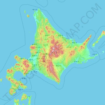
Name: Hokkaido Prefecture topographic map, elevation, terrain.
Location: Hokkaido Prefecture, Japan (41.15206 139.06728 45.71120 145.91603)
Average elevation: 81 m
Minimum elevation: -3 m
Maximum elevation: 2,072 m
Make a donation
Other topographic maps
Click on a map to view its topography, its elevation and its terrain.