
Make a donation
Okinawa Island topographic map
Click on the map to display elevation.
Make a donation
Okinawa Island
The Motobu Peninsula in the north has limestone layers and karst development. In the center and south is mainly a Ryukyu limestone layer and mudstone. The topography is flat, there are few hills over 100 m (328 ft) with very few rivers. The subtropical rains accelerates erosion so there are many drainages and uvala. The southern end of the island consists of uplifted coral reef, whereas the northern half has proportionally more igneous rock. The easily eroded limestone of the south has many caves, the most famous of which is Gyokusendō in Nanjō. The northernmost Cape Hedo is only 22 km (14 mi) away from Yoronjima. Cape Arasaki is the southernmost location of Okinawa island. It is sometimes confused with Cape Kiyanmisaki.
Make a donation
About this map
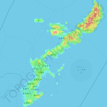
Name: Okinawa Island topographic map, elevation, terrain.
Location: Okinawa Island, Okinawa Prefecture, Japan (26.07446 127.62856 26.87552 128.32764)
Average elevation: 14 m
Minimum elevation: 0 m
Maximum elevation: 483 m
Make a donation
Other topographic maps
Click on a map to view its topography, its elevation and its terrain.