
Thank you for supporting this site ❤️
Make a donation
Make a donation
Saitama Prefecture topographic map
Click on the map to display elevation.
Thank you for supporting this site ❤️
Make a donation
Make a donation
Saitama Prefecture
The topography of Saitama Prefecture is largely divided by the Hachiōji Tectonic Line, which runs through Kodama, Ogawa, and Hannō, into the western mountain area and the eastern lowland area. The altitude, highest on the western side, gradually lowers eastward from mountain ranges to hills to plateaus to lowlands. The eastern lowlands and plateaus occupy 67.3% of the area.
Thank you for supporting this site ❤️
Make a donation
Make a donation
About this map
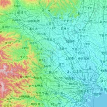
Name: Saitama Prefecture topographic map, elevation, terrain.
Location: Saitama Prefecture, Japan (35.75338 138.71136 36.28341 139.90033)
Average elevation: 230 m
Minimum elevation: -3 m
Maximum elevation: 2,041 m
Thank you for supporting this site ❤️
Make a donation
Make a donation
Other topographic maps
Click on a map to view its topography, its elevation and its terrain.