
Nikko topographic map
Click on the map to display elevation.
Nikko
Nikkō is a popular destination for Japanese and international tourists. Attractions include the mausoleum of shōgun Tokugawa Ieyasu at the Nikkō Tōshō-gū shrine, and that of his grandson Iemitsu (Iemitsu-byō Taiyū-in), and the Futarasan Shrine, which dates to the year 767 AD. There are many famous hot springs (onsen) in the area. Elevations range from 200 to 2,000 meters.
About this map
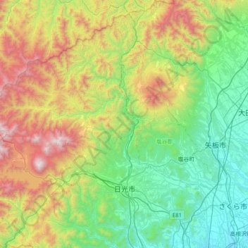
Name: Nikko topographic map, elevation, terrain.
Location: Nikko, Tochigi Prefecture, Japan (36.60097 139.32656 37.09190 139.85278)
Average elevation: 801 m
Minimum elevation: 125 m
Maximum elevation: 2,461 m
Other topographic maps
Click on a map to view its topography, its elevation and its terrain.