
Funabashi topographic map
Click on the map to display elevation.
Funabashi
Funabashi is located in northwestern Chiba Prefecture approximately 20 kilometers in either direction from the prefectural capital at Chiba and downtown Tokyo. The central area forms a flat diluvial upland of the Shimōsa Plateau. The city sits at an elevation of 20 to 30 meters above sea level, and is relatively flat. The highest point is 32.3 meters in Narashino 3-chome, and the lowest point is 0.2 meters in Minatomachi 1-chome. Funabashi is crossed by the Tone River, and the small Ebi River is located entirely within city limits. Funabashi formerly had wide, shallow beaches, but much of the coast has been industrialized and transformed by reclaimed land. The city extends for 13.86 kilometers east–west and 14.95 kilometers north–south.
About this map
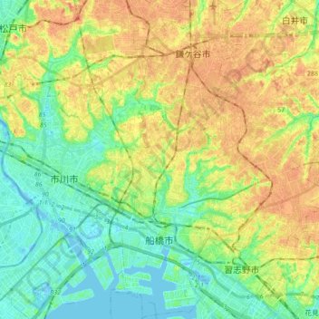
Name: Funabashi topographic map, elevation, terrain.
Location: Funabashi, Chiba Prefecture, Japan (35.65950 139.93872 35.79973 140.08968)
Average elevation: 17 m
Minimum elevation: -5 m
Maximum elevation: 36 m
Other topographic maps
Click on a map to view its topography, its elevation and its terrain.