
Shiga Prefecture topographic map
Click on the map to display elevation.
About this map
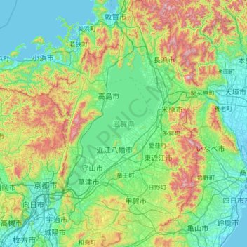
Name: Shiga Prefecture topographic map, elevation, terrain.
Location: Shiga Prefecture, Japan (34.79057 135.76373 35.70374 136.45504)
Average elevation: 270 m
Minimum elevation: -3 m
Maximum elevation: 1,338 m
Other topographic maps
Click on a map to view its topography, its elevation and its terrain.