
Make a donation
Shinano River topographic map
Click on the map to display elevation.
Make a donation
Shinano River
The Chikuma River originates in the Japanese Alps at altitudes of above 2,000 metres (6,600 ft) and has a basin in its own right of 7,163 square kilometres (2,766 sq mi). The Chikuma continues generally north-northeast joining with the Sai and changing name to the Shinano, after 214 kilometres (133 mi). The Chikuma, therefore, includes around sixty percent of the whole river system's basin and around 58 percent of the river's length.
Make a donation
About this map
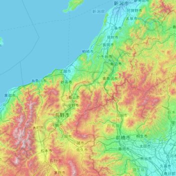
Name: Shinano River topographic map, elevation, terrain.
Location: Shinano River, 940-0093, Japan (35.94338 138.10594 37.94765 139.07165)
Average elevation: 565 m
Minimum elevation: -7 m
Maximum elevation: 3,055 m
Make a donation
Other topographic maps
Click on a map to view its topography, its elevation and its terrain.