
Nottinghamshire topographic map
Interactive map
Click on the map to display elevation.
About this map
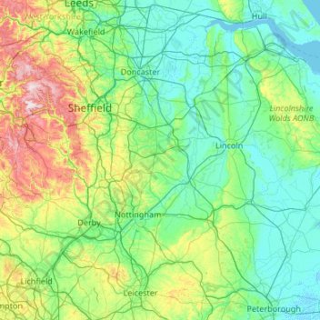
Name: Nottinghamshire topographic map, elevation, terrain.
Average elevation: 91 m
Minimum elevation: -3 m
Maximum elevation: 636 m
Other topographic maps
Click on a map to view its topography, its elevation and its terrain.
Shropshire Union Canal Newport Branch
United Kingdom > England > Telford and Wrekin > Newport
Average elevation: 77 m
Upper Mill Pond
United Kingdom > England > South Gloucestershire > Oldland Common
Average elevation: 42 m
Lincoln
United Kingdom > England > Lincolnshire
Lincoln lies at an altitude of 67 ft (20.4 m) by the River Witham up to 246 ft (75.0 m) on Castle Hill. It fills a gap in the Lincoln Cliff escarpment, which runs north and south through Central Lincolnshire, with altitudes up to 200 feet (61 metres). The city lies on the River Witham, which flows through this…
Average elevation: 29 m
Borough of Luton
The local climate around Luton is differentiated somewhat from much of South East England due to its position in the Chiltern Hills, meaning it tends to be 1–2 degrees Celsius cooler than the surrounding towns – often flights at Luton airport, lying 160 m (525 ft) above sea level, will be suspended when…
Average elevation: 146 m
Plymouth
In 1919, Nancy Astor was elected the first-ever female member of parliament to take office in the British Houses of Parliament for the constituency of Plymouth Sutton. She was elected to the seat vacated by her husband Waldorf Astor on his elevation to the peerage. Lady Astor was a vibrantly active campaigner…
Average elevation: 46 m
Whitwood Wharf
United Kingdom > England > Wakefield > Normanton and Altofts > Whitwood
Average elevation: 19 m
Windsor Castle
United Kingdom > England > Royal Borough of Windsor and Maidenhead > Windsor > Clewer Village
Average elevation: 23 m
Eastnor Castle
United Kingdom > England > Herefordshire > Eastnor > Wayend Street
Average elevation: 125 m
Lincolnshire
Lincolnshire has had a comparatively quiet history, being a rural county which was not heavily industrialised and faced little threat of invasion. In the fifth century what would become the county was settled by the invading Angles, who established the Kingdom of Lindsey in the north of the region. The late…
Average elevation: 26 m
Nottingham Canal
United Kingdom > England > Nottinghamshire > Nottingham > Beeston
Average elevation: 33 m
Bath
United Kingdom > England > Bath and North East Somerset
Bath is in the Avon Valley and is surrounded by limestone hills as it is near the southern edge of the Cotswolds, a designated Area of Outstanding Natural Beauty, and the limestone Mendip Hills rise around 7 miles (11 km) south of the city. The hills that surround and make up the city have a maximum altitude…
Average elevation: 100 m
Suffolk
The west of the county lies on more resistant Cretaceous chalk. This chalk is responsible for a sweeping tract of largely downland landscapes that stretches from Dorset in the south west to Dover in the south east and north through East Anglia to the Yorkshire Wolds. The chalk is less easily eroded so forms…
Average elevation: 35 m
Welton CP
United Kingdom > England > Lincolnshire > West Lindsey
The parish stretches from the ancient Ermine Street (A15) in the west, following a north-easterly shape to the Barlings Eau at its eastern end, of which the Welton Beck is a tributary, and is an example of a strip parish. Due to the low, flat topography of Lincolnshire, land had to be drained for agriculture…
Average elevation: 27 m
Lyme Regis
United Kingdom > England > Dorset
Lyme Regis is a coastal town in West Dorset, 25 miles (40 km) west of Dorchester and 25 miles (40 km) east of Exeter. It lies in Lyme Bay, on the English Channel coast at the Dorset–Devon border. At the 2011 census, it had a population of 3,671. The town has grown around the mouth of the River Lim (or Lym)…
Average elevation: 83 m
Salisbury
United Kingdom > England > Wiltshire
Bishop of Salisbury Hubert Walter was instrumental in the negotiations with Saladin during the Third Crusade, but he spent little time in his diocese prior to his elevation to archbishop of Canterbury. The brothers Herbert and Richard Poore succeeded him and began planning the relocation of the cathedral into…
Average elevation: 72 m
Bournemouth
United Kingdom > England > Bournemouth, Christchurch and Poole > Talbot Village
Average elevation: 17 m
Bakewell CP
United Kingdom > England > Derbyshire > Derbyshire Dales
The Manchester, Buxton, Matlock and Midlands Junction Railway opened Bakewell railway station in 1862, then became part of the Midland Railway and later of the LMS main line from London to Manchester. John Ruskin objected to what he saw as desecration of the Derbyshire countryside and to the fact that "a…
Average elevation: 194 m
Cambridge
United Kingdom > England > Cambridgeshire
The city, like most of the UK, has a maritime climate highly influenced by the Gulf Stream. Located in the driest region of Britain, Cambridge's rainfall averages around 570 mm (22.44 in) per year, around half the national average, The driest recent year was in 2011 with 380.4 mm (14.98 in) of rain at the…
Average elevation: 18 m