
Make a donation
Welton CP topographic map
Click on the map to display elevation.
Make a donation
Welton CP
The parish stretches from the ancient Ermine Street (A15) in the west, following a north-easterly shape to the Barlings Eau at its eastern end, of which the Welton Beck is a tributary, and is an example of a strip parish. Due to the low, flat topography of Lincolnshire, land had to be drained for agriculture to be successful. The larger drainage channels, many of which are parallel to each other, became boundaries between parishes, causing the long and thin shape of the parish. Welton's northern and southern extents are less obviously defined. The south follows Horncaslte Lane from the A15, before cutting through the town of Welton and William Farr School until it meets up with a small stream which is followed most of the way to the Barlings Eau. The northern boundary starts in the west at RAF Scampton's 1950s runway extension and follows a vague path through fields until once again reaching the Barlings Eau river near Snarford.
Make a donation
About this map
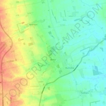
Name: Welton CP topographic map, elevation, terrain.
Location: Welton CP, West Lindsey, Lincolnshire, England, United Kingdom (53.29090 -0.54229 53.33040 -0.42435)
Average elevation: 27 m
Minimum elevation: 6 m
Maximum elevation: 61 m
Make a donation