
Thank you for supporting this site ❤️
Make a donation
Make a donation
Kirkfell Tarn topographic map
Click on the map to display elevation.
Thank you for supporting this site ❤️
Make a donation
Make a donation
About this map
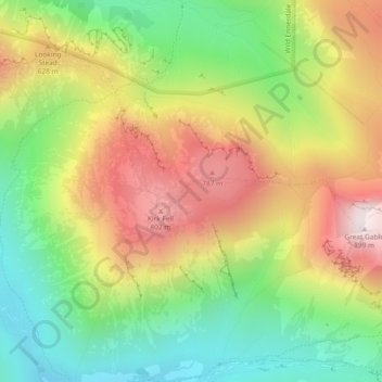
Name: Kirkfell Tarn topographic map, elevation, terrain.
Location: Kirkfell Tarn, Wasdale, Cumberland, England, United Kingdom (54.48450 -3.24045 54.48502 -3.23989)
Average elevation: 460 m
Minimum elevation: 100 m
Maximum elevation: 893 m
Thank you for supporting this site ❤️
Make a donation
Make a donation
Other topographic maps
Click on a map to view its topography, its elevation and its terrain.