
Suffolk topographic map
Click on the map to display elevation.
Suffolk
The west of the county lies on more resistant Cretaceous chalk. This chalk is responsible for a sweeping tract of largely downland landscapes that stretches from Dorset in the south west to Dover in the south east and north through East Anglia to the Yorkshire Wolds. The chalk is less easily eroded so forms the only significant hills in the county. The highest point in the county is Great Wood Hill, with an elevation of 128 metres (420 ft). It is the highest point of the Newmarket Ridge and is near the villages of Rede and Chedburgh.
About this map
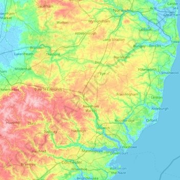
Name: Suffolk topographic map, elevation, terrain.
Location: Suffolk, England, United Kingdom (51.93176 0.33997 52.55022 1.76891)
Average elevation: 35 m
Minimum elevation: -4 m
Maximum elevation: 130 m
Other topographic maps
Click on a map to view its topography, its elevation and its terrain.
Eastnor Castle
United Kingdom > England > Herefordshire > Eastnor > Wayend Street
Average elevation: 125 m
Windsor Castle
United Kingdom > England > Royal Borough of Windsor and Maidenhead > Windsor > Clewer Village
Average elevation: 23 m
Chard
United Kingdom > England > Somerset
Chard is a town and a civil parish in the English county of Somerset. It lies on the A30 road near the Devon and Dorset borders, 15 miles (24 km) south west of Yeovil. The parish has a population of approximately 14,000 and, at an elevation of 121 metres (397 ft), Chard is the southernmost and one of the…
Average elevation: 135 m
Shropshire Union Canal Newport Branch
United Kingdom > England > Telford and Wrekin > Newport
Average elevation: 77 m
Littlestone on Sea
United Kingdom > England > Kent > Folkestone and Hythe District > New Romney
Average elevation: 1 m
Ashurst Bridge
United Kingdom > England > Hampshire > New Forest > West Totton
Average elevation: 17 m
Upper Mill Pond
United Kingdom > England > South Gloucestershire > Oldland Common
Average elevation: 42 m
Thames Head
United Kingdom > England > Gloucestershire > Cotswold District > Kemble
Average elevation: 117 m
Clapham
In 1848, Clapham was described in the Topographical Dictionary of England as a village which "has for many years, been one of the most respectable in the environs of the metropolis". At this time, the patronage of Holy Trinity church belonged to the Atkins family.
Average elevation: 22 m
Whitwood Wharf
United Kingdom > England > Wakefield > Normanton and Altofts > Whitwood
Average elevation: 19 m
Temple Guiting
United Kingdom > England > Gloucestershire > Cotswold District
Average elevation: 241 m
Harrogate
United Kingdom > England > North Yorkshire
Harrogate is situated on the edge of the Yorkshire Dales, with the Vale of York to the east and the upland Yorkshire Dales to the west and north-west. It has a dry and mild climate, typical of places in the rain shadow of the Pennines. It is on the A59 from Skipton to York. At an altitude of between 100 and…
Average elevation: 106 m
Hull
United Kingdom > England > Kingston upon Hull
Kingston upon Hull is on the northern bank of the Humber Estuary. The city centre is west of the River Hull and close to the Humber. The city is built upon alluvial and glacial deposits which overlie chalk rocks but the underlying chalk has no influence on the topography. The land within the city is generally…
Average elevation: 21 m
Sawmills
United Kingdom > England > Derbyshire > Amber Valley > Ripley > Fritchley
Average elevation: 119 m
Scarborough
United Kingdom > England > North Yorkshire
The climate is temperate with mild summers and cool, windy, winters. The hottest months of the year are July and August, with temperatures reaching an average high of 17 °C and falling to 11 °C at night. The average daytime temperatures in January are 4 °C, falling to 1 °C at night. The station's elevation…
Average elevation: 39 m
Upper Rissington
United Kingdom > England > Gloucestershire > Cotswold District
Average elevation: 184 m
Holme-on-Spalding-Moor
United Kingdom > England > East Riding of Yorkshire > Holme-on-Spalding-Moor
Average elevation: 8 m
Clewer Village
United Kingdom > England > Royal Borough of Windsor and Maidenhead
Average elevation: 26 m