
Thank you for supporting this site ❤️
Make a donation
Make a donation
Yeovil topographic map
Click on the map to display elevation.
Thank you for supporting this site ❤️
Make a donation
Make a donation
About this map
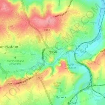
Name: Yeovil topographic map, elevation, terrain.
Location: Yeovil, Somerset, England, United Kingdom (50.92679 -2.67151 50.95660 -2.59799)
Average elevation: 63 m
Minimum elevation: 22 m
Maximum elevation: 113 m
Thank you for supporting this site ❤️
Make a donation
Make a donation
Other topographic maps
Click on a map to view its topography, its elevation and its terrain.
Chard
United Kingdom > England > Somerset
Chard is a town and a civil parish in the English county of Somerset. It lies on the A30 road near the Devon and Dorset borders, 15 miles (24 km) south west of Yeovil. The parish has a population of approximately 14,000 and, at an elevation of 121 metres (397 ft), Chard is the southernmost and one of the…
Average elevation: 135 m