
Thank you for supporting this site ❤️
Make a donation
Make a donation
Canterbury topographic map
Click on the map to display elevation.
Thank you for supporting this site ❤️
Make a donation
Make a donation
About this map
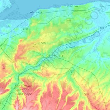
Name: Canterbury topographic map, elevation, terrain.
Location: Canterbury, Kent, England, United Kingdom (51.17719 0.93720 51.38254 1.25007)
Average elevation: 51 m
Minimum elevation: -1 m
Maximum elevation: 178 m
Thank you for supporting this site ❤️
Make a donation
Make a donation
Other topographic maps
Click on a map to view its topography, its elevation and its terrain.
Littlestone on Sea
United Kingdom > England > Kent > Folkestone and Hythe District > New Romney
Average elevation: 1 m