
Thank you for supporting this site ❤️
Make a donation
Make a donation
Carharrack topographic map
Click on the map to display elevation.
Thank you for supporting this site ❤️
Make a donation
Make a donation
About this map
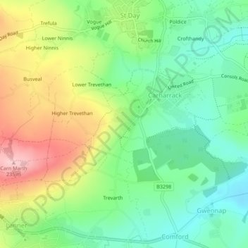
Name: Carharrack topographic map, elevation, terrain.
Location: Carharrack, Cornwall, England, United Kingdom (50.22117 -5.20004 50.23373 -5.17205)
Average elevation: 119 m
Minimum elevation: 46 m
Maximum elevation: 234 m
Thank you for supporting this site ❤️
Make a donation
Make a donation
Other topographic maps
Click on a map to view its topography, its elevation and its terrain.