
Tonstad topographic map
Interactive map
Click on the map to display elevation.
About this map
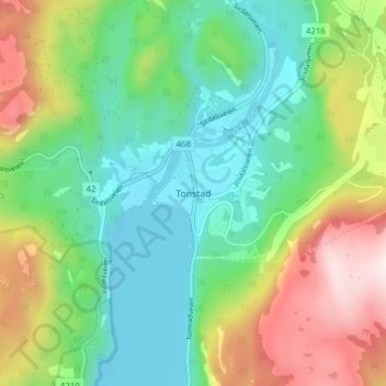
Name: Tonstad topographic map, elevation, terrain.
Location: Tonstad, Sirdal, Agder, 4440, Noorwegen (58.64455 6.69607 58.68455 6.73607)
Average elevation: 253 m
Minimum elevation: 43 m
Maximum elevation: 667 m
Other topographic maps
Click on a map to view its topography, its elevation and its terrain.
Ugelen
Noorwegen > Agder > Kristiansand
Ugelen, Kristiansand, Agder, 4625, Noorwegen
Average elevation: 4 m