
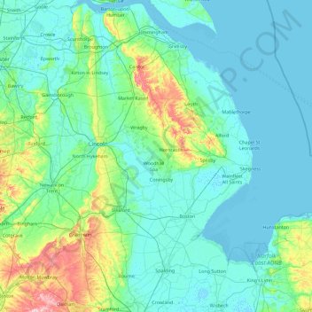
Lincolnshire topographic map
Interactive map
Click on the map to display elevation.
About this map
Name: Lincolnshire topographic map, elevation, terrain.
Location: Lincolnshire, England, United Kingdom (52.64022 -0.95001 53.72446 0.35797)
Average elevation: 26 m
Minimum elevation: -2 m
Maximum elevation: 220 m
Lincolnshire has had a comparatively quiet history, being a rural county which was not heavily industrialised and faced little threat of invasion. In the fifth century what would become the county was settled by the invading Angles, who established the Kingdom of Lindsey in the north of the region. The late Middle Ages were a particularly prosperous period, when wealth from wool trade facilitated the building of grand churches such as St Botolph's Church, Boston. During the Second World War the relatively flat topography of the county made it an important base for the Royal Air Force, which built several airfields and based two bomber squadrons in the area.
Other topographic maps
Click on a map to view its topography, its elevation and its terrain.
Wythenshawe
United Kingdom > England > Manchester
Wythenshawe, Manchester, Greater Manchester, England, M22 5RE, United Kingdom
Average elevation: 54 m
Kirkfell Tarn
United Kingdom > England > Cumberland
Kirkfell Tarn, Wasdale, Cumberland, England, United Kingdom
Average elevation: 460 m
Huddersfield
United Kingdom > England > Kirklees
Huddersfield, Kirklees, West Yorkshire, England, HD1 2AA, United Kingdom
Average elevation: 145 m
Royal Borough of Kensington and Chelsea
United Kingdom > England > London
Royal Borough of Kensington and Chelsea, London, Greater London, England, United Kingdom
Average elevation: 18 m
Courtlands
United Kingdom > England > Hertfordshire > Watford
Courtlands, Watford, Hertfordshire, England, WD24 5JT, United Kingdom
Average elevation: 85 m
Exmouth
United Kingdom > England > Devon > East Devon
Exmouth, East Devon, Devon, England, United Kingdom
Average elevation: 28 m
Waterbeach
United Kingdom > England > Cambridgeshire > South Cambridgeshire
Waterbeach, South Cambridgeshire, Cambridgeshire, Cambridgeshire and Peterborough, England, United Kingdom
Average elevation: 4 m
Belton
United Kingdom > England > Leicestershire > North West Leicestershire
Belton, North West Leicestershire, Leicestershire, England, United Kingdom
Average elevation: 90 m
London Borough of Newham
United Kingdom > England > London
London Borough of Newham, London, Greater London, England, United Kingdom
Average elevation: 8 m
Canterbury
United Kingdom > England > Kent
Canterbury, Kent, England, United Kingdom
Average elevation: 51 m
Leicester
United Kingdom > England > Leicestershire
Leicester, Leicestershire, England, LE1 5YA, United Kingdom
Average elevation: 109 m
Witchampton
United Kingdom > England > Dorset
Witchampton, Dorset, England, United Kingdom
Average elevation: 47 m
Nottingham Canal
United Kingdom > England > Nottinghamshire > Nottingham > Beeston
Nottingham Canal, Beeston, Nottingham, Nottinghamshire, England, United Kingdom
Average elevation: 33 m
Kinsham
United Kingdom > England > Worcestershire > Wychavon > Bredon
Kinsham, Bredon, Wychavon, Worcestershire, England, GL20 8GF, United Kingdom
Average elevation: 29 m
South Cambridgeshire
United Kingdom > England > Cambridgeshire
South Cambridgeshire, Cambridgeshire, Cambridgeshire and Peterborough, England, United Kingdom
Average elevation: 42 m
Bath
United Kingdom > England > Bath and North East Somerset
Bath, Bath and North East Somerset, West of England, England, United Kingdom
Average elevation: 100 m
Wimborne Minster
United Kingdom > England > Dorset
Wimborne Minster, Dorset, England, United Kingdom
Average elevation: 31 m
West Northamptonshire
West Northamptonshire, England, United Kingdom
Average elevation: 111 m
Thames Head
United Kingdom > England > Gloucestershire > Cotswold District > Kemble
Thames Head, Kemble, Cotswold District, Gloucestershire, England, GL7 6NZ, United Kingdom
Average elevation: 117 m
Temple Guiting
United Kingdom > England > Gloucestershire > Cotswold District
Temple Guiting, Cotswold District, Gloucestershire, England, GL54 5RP, United Kingdom
Average elevation: 241 m
Welton CP
United Kingdom > England > Lincolnshire > West Lindsey
Welton CP, West Lindsey, Lincolnshire, England, United Kingdom
Average elevation: 27 m
Ross-on-Wye
United Kingdom > England > Herefordshire
Ross-on-Wye, Herefordshire, England, United Kingdom
Average elevation: 61 m
Biddenden
United Kingdom > England > Kent > Ashford
Biddenden, Ashford, Kent, England, United Kingdom
Average elevation: 46 m
Maidstone
United Kingdom > England > Kent
Maidstone, Kent, England, United Kingdom
Average elevation: 70 m
Mount
United Kingdom > England > Kirklees
Mount, Kirklees, West Yorkshire, England, HD3 3UQ, United Kingdom
Average elevation: 219 m
Borough of Swale
United Kingdom > England > Kent
Borough of Swale, Kent, England, United Kingdom
Average elevation: 50 m
Read
United Kingdom > England > Lancashire > Ribble Valley
Read, Ribble Valley, Lancashire, England, United Kingdom
Average elevation: 114 m
Chippenham
United Kingdom > England > Wiltshire
Chippenham, Wiltshire, England, United Kingdom
Average elevation: 63 m
Charlwood
United Kingdom > England > Surrey > Mole Valley
Charlwood, Mole Valley, Surrey, England, United Kingdom
Average elevation: 72 m
Charnwood
United Kingdom > England > Leicestershire
Charnwood, Leicestershire, England, United Kingdom
Average elevation: 92 m
Yeovil
United Kingdom > England > Somerset
Yeovil, Somerset, England, United Kingdom
Average elevation: 63 m
Okehampton
United Kingdom > England > Devon > West Devon
Okehampton, West Devon, Devon, England, United Kingdom
Average elevation: 206 m
Lyme Regis
United Kingdom > England > Dorset
Lyme Regis, Dorset, England, United Kingdom
Average elevation: 83 m
Wearne
United Kingdom > England > Somerset > Huish Episcopi
Wearne, Huish Episcopi, Somerset, England, TA10 9HB, United Kingdom
Average elevation: 32 m
Taunton
United Kingdom > England > Somerset
Taunton, Somerset, England, TA1 1JD, United Kingdom
Average elevation: 39 m
Salisbury
United Kingdom > England > Wiltshire
Salisbury, Wiltshire, England, United Kingdom
Average elevation: 72 m
Carharrack
United Kingdom > England > Cornwall
Carharrack, Cornwall, England, United Kingdom
Average elevation: 119 m
Sherborne
United Kingdom > England > Dorset
Sherborne, Dorset, England, United Kingdom
Average elevation: 88 m
Swanage
United Kingdom > England > Dorset
Swanage, Dorset, England, United Kingdom
Average elevation: 38 m
Gillingham
United Kingdom > England > Dorset
Gillingham, Dorset, England, United Kingdom
Average elevation: 93 m
Trowbridge
United Kingdom > England > Wiltshire > Trowbridge
Trowbridge, Wiltshire, England, United Kingdom
Average elevation: 47 m
Chard
United Kingdom > England > Somerset
Chard, Somerset, England, TA20 2AX, United Kingdom
Average elevation: 135 m
Mansfield
United Kingdom > England > Nottinghamshire
Mansfield, Nottinghamshire, England, United Kingdom
Average elevation: 117 m
Northampton
United Kingdom > England > West Northamptonshire
Northampton, West Northamptonshire, England, United Kingdom
Average elevation: 89 m
Loughborough
United Kingdom > England > Leicestershire > Charnwood
Loughborough, Charnwood, Leicestershire, England, LE11 5BJ, United Kingdom
Average elevation: 61 m
Bakewell CP
United Kingdom > England > Derbyshire > Derbyshire Dales
Bakewell CP, Derbyshire Dales, Derbyshire, England, United Kingdom
Average elevation: 194 m
Hull
United Kingdom > England > Kingston upon Hull
Hull, Kingston upon Hull, England, HU1 3RJ, United Kingdom
Average elevation: 21 m