Geolocate

Taunton topographic map

Interactive map

Click on the map to display elevation.

About this map

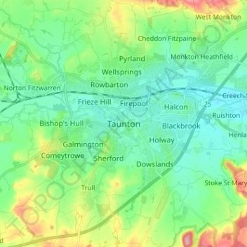
Name: Taunton topographic map, elevation, terrain.

Location: Taunton, Somerset, England, TA1 1JD, United Kingdom (50.97479 -3.14291 51.05479 -3.06291)

Average elevation: 39 m

Minimum elevation: 7 m

Maximum elevation: 122 m

Other topographic maps

Click on a map to view its topography, its elevation and its terrain.

Yeovil

United Kingdom > England > Somerset

Yeovil, Somerset, England, United Kingdom

Average elevation: 63 m

Wearne

United Kingdom > England > Somerset > Huish Episcopi

Wearne, Huish Episcopi, Somerset, England, TA10 9HB, United Kingdom

Average elevation: 32 m

Chard

United Kingdom > England > Somerset

Chard, Somerset, England, TA20 2AX, United Kingdom

Average elevation: 135 m