
Make a donation
South Sumatra topographic map
Click on the map to display elevation.
Make a donation
South Sumatra
On the east coast the land consists of swamps and brackets which are affected by tides. Its vegetation is in the form of palmate plants and mangrove. A little more western is a vast lowland. Far to the west near the border of Bengkulu and Jambi lies the Bukit Barisan mountains, which divides South Sumatra and is a mountainous area with an altitude of 900 to 1,200 metres (3,000 to 3,900 ft) above sea level. Barisan Hill consists of the summit of Mount Seminung (1,964 metres or 6,444 feet asl), Mount Dempo (3,159 metres or 10,364 feet asl), Mount Patah (1,107 metres or 3,632 feet asl), and Mount Bungkuk (2,125 metres or 6,972 feet asl). To the west of Bukit Barisan is a slope. In the Bukit Barisan valley there are areas of rubber, oil palm, and agriculture plantations, especially coffee, tea and vegetables. Mount Dempo is the highest point in the province.
Make a donation
About this map
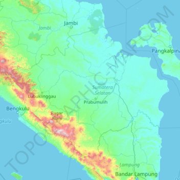
Name: South Sumatra topographic map, elevation, terrain.
Location: South Sumatra, Sumatra, Indonesia (-4.92416 102.05323 -1.51384 106.60263)
Average elevation: 123 m
Minimum elevation: -3 m
Maximum elevation: 2,774 m
Make a donation
Other topographic maps
Click on a map to view its topography, its elevation and its terrain.
Semarang
Semarang is located on the northern coast of Java. The city of Semarang is one of the important cities located on the north coast of Java and as the main hub connecting Jakarta and Surabaya, and cities in the southern interior of Java Surakarta and Yogyakarta. Semarang City has a height ranging from 2 m (6.6…
Average elevation: 88 m
Telagabodas
Mount Talagabodas or Mount Telagabodas (which means Mount of White Lake (refer to white crater lake) in Sundanese) is a stratovolcano in West Java, Indonesia. The volcano is about 25 km to the east of the town of Garut and is built up of andesitic lavas and pyroclastics. Fumaroles, mud pots and hot springs are…
Average elevation: 1,735 m
Make a donation
Make a donation
Make a donation
Make a donation
Make a donation
Make a donation
Make a donation
Make a donation
Make a donation
Make a donation
Sangeang Api
Indonesia > West Nusa Tenggara
Since mid-June 2013, authorities had put the volcano on 'high alert' for a possible eruption. On May 30, 2014, a major eruption occurred at around 3:55 p.m. local time. Farmers working on the island were evacuated. Ash and smoke quickly rose to an altitude of 15–20 km (≈10–16 miles) into the sky. By the…
Average elevation: 1,382 m
Make a donation
Karangetang [Api Siau]
Indonesia > North Sulawesi > Kepulauan Siau Tagulandang Biaro
Average elevation: 1,146 m
Make a donation
Make a donation
Make a donation
Make a donation
Make a donation
Bandung
Indonesia > West Java > Bandung
Bandung, the capital of West Java province, located about 180 kilometres (110 mi) southeast of Jakarta, is the third-largest city in Indonesia. Its elevation is 768 metres (2,520 ft) above sea level and is surrounded by up to 2,400 metres (7,900 feet) high Late Tertiary and Quaternary volcanic terrain. The 400…
Average elevation: 879 m
Make a donation
Make a donation
Make a donation
Make a donation
Make a donation
Make a donation
Sidoluhur
Indonesia > Special Region of Yogyakarta > Sleman Regency > Sidoagung
Average elevation: 120 m