
Thank you for supporting this site ❤️
Make a donation
Make a donation
Jaya Mekar topographic map
Click on the map to display elevation.
Thank you for supporting this site ❤️
Make a donation
Make a donation
About this map
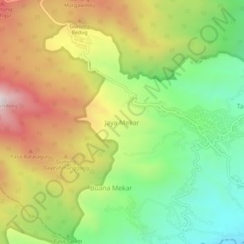
Name: Jaya Mekar topographic map, elevation, terrain.
Location: Jaya Mekar, Sumedang, West Java, Java, Indonesia (-6.98084 107.97756 -6.94084 108.01756)
Average elevation: 1,090 m
Minimum elevation: 682 m
Maximum elevation: 1,599 m
Thank you for supporting this site ❤️
Make a donation
Make a donation