
Cupang topographic map
Click on the map to display elevation.
About this map
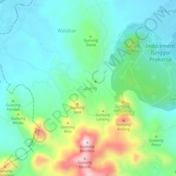
Name: Cupang topographic map, elevation, terrain.
Location: Cupang, West Java, Indonesia (-6.74268 108.36159 -6.70268 108.40159)
Average elevation: 163 m
Minimum elevation: 24 m
Maximum elevation: 533 m
Other topographic maps
Click on a map to view its topography, its elevation and its terrain.
Bogor
The city is situated in the western part of Java island, about 53 km south of the capital Jakarta and 85 km northwest of Bandung, the administrative center of West Java Province. Bogor spreads over a basin near volcanoes Salak, which peaks at about 12 km south, and Mount Gede whose top is 22–25 km south-east…
Average elevation: 310 m