
Zambezi River topographic map
Interactive map
Click on the map to display elevation.
About this map
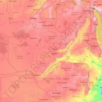
Name: Zambezi River topographic map, elevation, terrain.
Location: Zambezi River, Zambia (-18.62317 22.54314 -11.07455 36.46460)
Average elevation: 1,015 m
Minimum elevation: 0 m
Maximum elevation: 2,822 m
The river flows to the southwest into Angola for about 240 km (150 mi), then is joined by sizeable tributaries such as the Luena and the Chifumage flowing from highlands to the north-west. It turns south and develops a floodplain, with extreme width variation between the dry and rainy seasons. It enters dense evergreen Cryptosepalum dry forest, though on its western side, Western Zambezian grasslands also occur. Where it re-enters Zambia, it is nearly 400 m (1,300 ft) wide in the rainy season and flows rapidly, with rapids ending in the Chavuma Falls, where the river flows through a rocky fissure. The river drops about 400 m (1,300 ft) in elevation from its source at 1,500 m (4,900 ft) to the Chavuma Falls at 1,100 m (3,600 ft), in a distance of about 400 km (250 mi). From this point to the Victoria Falls, the level of the basin is very uniform, dropping only by another 180 m (590 ft) in a distance around 800 km (500 mi).
Other topographic maps
Click on a map to view its topography, its elevation and its terrain.
Lumwana
Zambia > North-Western Province
Lumwana, Kalumbila District, North-Western Province, Zambia
Average elevation: 1,376 m
Lusaka
Lusaka, Lusaka District, Lusaka Province, 10101, Zambia
Average elevation: 1,227 m
Lufwanyama
Lufwanyama, Lufwanyama District, Copperbelt Province, Zambia
Average elevation: 1,209 m
Kalumbila District
Zambia > North-Western Province
Kalumbila District, North-Western Province, Zambia
Average elevation: 1,312 m
Makoko
Makoko, Kaputa District, Northern Province, Zambia
Average elevation: 1,044 m
Kasama
Kasama, Kasama District, Northern Province, Zambia
Average elevation: 1,327 m
Vubwi District
Vubwi District, Eastern Province, Zambia
Average elevation: 1,050 m
Kumbula Island
Zambia > Northern Province > Mpulungu
Kumbula Island, Mpulungu, Mpulungu District, Northern Province, Zambia
Average elevation: 776 m
Mabonde
Mabonde, Chitambo District, Central Province, Zambia
Average elevation: 1,511 m
Mfuwe
Mfuwe, Mambwe District, Eastern Province, Zambia
Average elevation: 526 m
Livingstone
Livingstone, Livingstone District, Southern Province, Zambia
Average elevation: 961 m
Mufumbwe
Zambia > North-Western Province
Mufumbwe, Mufumbwe District, North-Western Province, Zambia
Average elevation: 1,164 m
Senanga
Zambia > Western Province, Zambia > Senanga
Senanga, Senanga District, Western Province, Zambia, Zambia
Average elevation: 1,016 m
Lufwanyama District
Lufwanyama District, Copperbelt Province, Zambia
Average elevation: 1,238 m
Mongu
Zambia > Western Province, Zambia > Mongu
Mongu, Mongu District, Western Province, Zambia, Zambia
Average elevation: 1,037 m
Kafue
Zambia > Lusaka Province > Kafue
Kafue, Kafue District, Lusaka Province, Zambia
Average elevation: 1,028 m
Victoria Falls
Zambia > Southern Province > Livingstone
Victoria Falls, Livingstone, Livingstone District, Southern Province, Zambia
Average elevation: 875 m
Ndola
Ndola, Ndola District, Copperbelt Province, Zambia
Average elevation: 1,287 m
Mufumbwe District
Zambia > North-Western Province
Mufumbwe District, North-Western Province, Zambia
Average elevation: 1,172 m
Chipata
Chipata, Chipata District, Eastern Province, Zambia
Average elevation: 1,133 m
Mwembeshi
Mwembeshi, Chilanga District, Lusaka Province, Zambia
Average elevation: 1,108 m
Kalomo
Kalomo, Kalomo District, Southern Province, Zambia
Average elevation: 1,240 m
Moomba
Zambia > Southern Province > Moomba
Moomba, Namwala District, Southern Province, Zambia
Average elevation: 999 m
Zambezi
Zambia > Southern Province > Katombora
Zambezi, Katombora, Kazungula District, Southern Province, Zambia
Average elevation: 966 m
Chama
Zambia > Muchinga Province > Chama
Chama, Chama District, Muchinga Province, Zambia
Average elevation: 787 m
Kitwe
Kitwe, Kitwe District, Copperbelt Province, 1001, Zambia
Average elevation: 1,233 m
Senkobo
Zambia > Southern Province > Senkobo
Senkobo, Livingstone District, Southern Province, Zambia
Average elevation: 1,103 m
Victoria Falls
Zambia > Southern Province > Livingstone
Victoria Falls, Livingstone, Southern Province, Zambia
Average elevation: 875 m
Sesheke
Sesheke, Sesheke District, Western Province, Zambia
Average elevation: 959 m
Luanshya
Zambia > Copperbelt Province > Luanshya
Luanshya, Copperbelt Province, Zambia
Average elevation: 1,228 m
Siavonga
Zambia > Southern Province > Siavonga
Siavonga, Southern Province, Zambia
Average elevation: 514 m
Victoria Falls
Zambia > Southern Province > Livingstone
Victoria Falls, Livingstone, Southern Province, Zambia
Average elevation: 877 m
Chinsali
Chinsali, Chinsali District, Muchinga Province, Zambia
Average elevation: 1,294 m
Mbala
Mbala, Mbala District, Northern Province, Zambia
Average elevation: 1,632 m
Kaoma
Kaoma, Kaoma District, Western Province, Zambia
Average elevation: 1,160 m
Kabwe
Kabwe, Kabwe District, Central Province, Zambia
Average elevation: 1,187 m