
Lufwanyama District topographic map
Interactive map
Click on the map to display elevation.
About this map
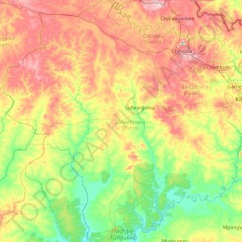
Name: Lufwanyama District topographic map, elevation, terrain.
Location: Lufwanyama District, Copperbelt Province, Zambia (-13.52708 26.85794 -12.33788 28.21724)
Average elevation: 1,238 m
Minimum elevation: 1,125 m
Maximum elevation: 1,456 m
Other topographic maps
Click on a map to view its topography, its elevation and its terrain.
Lufwanyama
Lufwanyama, Lufwanyama District, Copperbelt Province, Zambia
Average elevation: 1,209 m
Ndola
Ndola, Ndola District, Copperbelt Province, Zambia
Average elevation: 1,287 m
Kitwe
Kitwe, Kitwe District, Copperbelt Province, 1001, Zambia
Average elevation: 1,233 m
Luanshya
Zambia > Copperbelt Province > Luanshya
Luanshya, Copperbelt Province, Zambia
Average elevation: 1,228 m