
Kasama topographic map
Interactive map
Click on the map to display elevation.
About this map
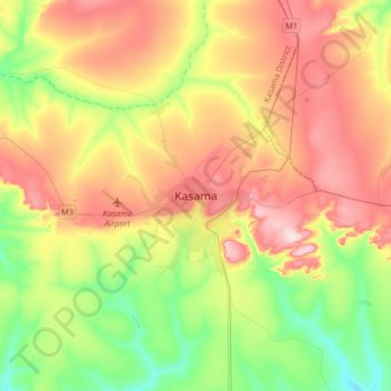
Name: Kasama topographic map, elevation, terrain.
Location: Kasama, Kasama District, Northern Province, Zambia (-10.36449 31.02772 -10.04449 31.34772)
Average elevation: 1,327 m
Minimum elevation: 1,219 m
Maximum elevation: 1,460 m
Other topographic maps
Click on a map to view its topography, its elevation and its terrain.
Makoko
Makoko, Kaputa District, Northern Province, Zambia
Average elevation: 1,044 m
Kumbula Island
Zambia > Northern Province > Mpulungu
Kumbula Island, Mpulungu, Mpulungu District, Northern Province, Zambia
Average elevation: 776 m
Mbala
Mbala, Mbala District, Northern Province, Zambia
Average elevation: 1,632 m