
Muchinga Province topographic map
Interactive map
Click on the map to display elevation.
About this map
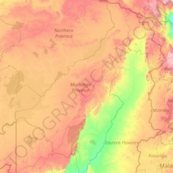
Name: Muchinga Province topographic map, elevation, terrain.
Location: Muchinga Province, Zambia (-13.43384 29.78022 -9.08311 33.70950)
Average elevation: 1,180 m
Minimum elevation: 473 m
Maximum elevation: 2,875 m
Other topographic maps
Click on a map to view its topography, its elevation and its terrain.
Chama
Zambia > Muchinga Province > Chama
Chama, Chama District, Muchinga Province, Zambia
Average elevation: 787 m
Chinsali
Chinsali, Chinsali District, Muchinga Province, Zambia
Average elevation: 1,294 m