
Chipata topographic map
Interactive map
Click on the map to display elevation.
About this map
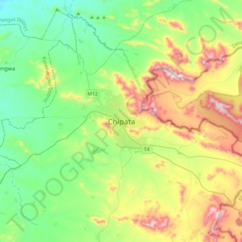
Name: Chipata topographic map, elevation, terrain.
Location: Chipata, Chipata District, Eastern Province, Zambia (-13.79913 32.48584 -13.47913 32.80584)
Average elevation: 1,133 m
Minimum elevation: 882 m
Maximum elevation: 1,668 m
Chipata is located approximately 570 kilometres (354 mi) east of Lusaka, the capital city of Zambia. This is about 150 kilometres (93 mi) west of Lilongwe, the capital city of Malawi. The geographical coordinates of Chipata are 13°38'43.0"S, 32°38'47.0"E (Latitude:13°38'43.0"S; Longitude:32°38'47.0"E). The average elevation of Chipata is 1,181 metres (3,875 ft), above sea level.
Other topographic maps
Click on a map to view its topography, its elevation and its terrain.
Vubwi District
Vubwi District, Eastern Province, Zambia
Average elevation: 1,050 m
Mfuwe
Mfuwe, Mambwe District, Eastern Province, Zambia
Average elevation: 526 m