
Mufumbwe District topographic map
Interactive map
Click on the map to display elevation.
About this map
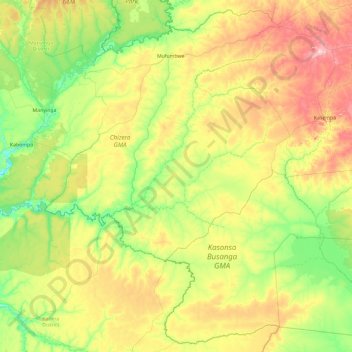
Name: Mufumbwe District topographic map, elevation, terrain.
Location: Mufumbwe District, North-Western Province, Zambia (-14.63409 24.33043 -12.89258 26.21364)
Average elevation: 1,172 m
Minimum elevation: 1,049 m
Maximum elevation: 1,477 m
Other topographic maps
Click on a map to view its topography, its elevation and its terrain.
Lumwana
Zambia > North-Western Province
Lumwana, Kalumbila District, North-Western Province, Zambia
Average elevation: 1,376 m
Kalumbila District
Zambia > North-Western Province
Kalumbila District, North-Western Province, Zambia
Average elevation: 1,312 m
Mufumbwe
Zambia > North-Western Province
Mufumbwe, Mufumbwe District, North-Western Province, Zambia
Average elevation: 1,164 m