
Delhi topographic map
Interactive map
Click on the map to display elevation.
Delhi
The topography of the medieval fort Purana Qila on the banks of the river Yamuna matches the literary description of the citadel Indraprastha in the Sanskrit epic Mahabharata; however, excavations in the area have revealed no signs of an ancient built environment. From the early 13th century until the mid-19th century, Delhi was the capital of two major empires, the Delhi Sultanate and the Mughal Empire, which covered large parts of South Asia. All three UNESCO World Heritage Sites in the city, the Qutub Minar, Humayun's Tomb, and the Red Fort, belong to this period. Delhi was the early centre of Sufism and Qawwali music. The names of Nizamuddin Auliya and Amir Khusrau are prominently associated with it. The Khariboli dialect of Delhi was part of a linguistic development that gave rise to the literature of Urdu and later Modern Standard Hindi. Major Urdu poets from Delhi include Mir Taqi Mir and Mirza Ghalib. Delhi was a notable centre of the Indian Rebellion of 1857. In 1911, New Delhi, a southern region within Delhi, became the capital of the British Indian Empire. During the Partition of India in 1947, Delhi was transformed from a Mughal city to a Punjabi one, losing two-thirds of its Muslim residents, in part due to the pressure brought to bear by arriving Hindu and Sikh refugees from western Punjab. After independence in 1947, New Delhi continued as the capital of the Dominion of India, and after 1950 of the Republic of India.
About this map
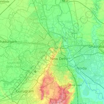
Name: Delhi topographic map, elevation, terrain.
Location: Delhi, India (28.40463 76.83884 28.88345 77.34660)
Average elevation: 218 m
Minimum elevation: 192 m
Maximum elevation: 315 m
Other topographic maps
Click on a map to view its topography, its elevation and its terrain.
Itanagar
India > Arunachal Pradesh > Itanagar EAC
Itanagar is located at 27°06′N 93°37′E / 27.1°N 93.62°E / 27.1; 93.62. It has an average elevation of 320 metres.
Average elevation: 539 m
Chennai
Chennai is located on the southeastern coast of India in the northeastern part of Tamil Nadu on a flat coastal plain known as the Eastern Coastal Plains with an average elevation of 6.7 m (22 ft) and highest point at 60 m (200 ft). Chennai's soil is mostly clay, shale and sandstone. Clay underlies most of the…
Average elevation: 7 m
Polavaram Project Left Channel
India > Andhra Pradesh > Nakkapalle > Sitampalem
Average elevation: 42 m
Ichalkaranji
India > Maharashtra > Hatkanangle
Ichalkaranji is located at 16°42′N 74°28′E / 16.7°N 74.47°E / 16.7; 74.47. It has an average elevation of 538 metres (1768 ft).
Average elevation: 562 m
Bengaluru
India > Karnataka > Bangalore North
Bangalore (/ˈbæŋɡəlɔːr, ˌbæŋɡəˈlɔːr/ BANG-gə-lor, -LOR), officially Bengaluru (Kannada pronunciation: [ˈbeŋgɐɭuːɾu] ; ISO: Beṁgaḷūru), is the capital and largest city of the southern Indian state of Karnataka. It has a population of more than 8 million and a metropolitan…
Average elevation: 879 m
Jamshedpur
India > Jharkhand > Golmuri-Cum-Jugsalai
Jamshedpur is situated in the southern end of the state of Jharkhand and is bordered by the states of Odisha and West Bengal. The average elevation of the city is 135 metres while the range is from 129 m to 151 m. Total geographical area of Jamshedpur is 224 km square. Jamshedpur is primarily located in a…
Average elevation: 195 m
Leh
India > Ladakh > Leh Tehsil
Leh (/ˈleɪ/) is a city in Indian-administered Ladakh in the disputed Kashmir region. It is the largest city and the joint capital of Ladakh. Leh, located in the Leh district, was also the historical capital of the Kingdom of Ladakh. The seat of the kingdom, Leh Palace, the former residence of the royal…
Average elevation: 3,653 m
Guna
India > Madhya Pradesh > Guna NagarTahsil
Guna is located at 24°39′N 77°19′E / 24.65°N 77.32°E / 24.65; 77.32. It has an average elevation of 474 metres (1555 ft).
Average elevation: 474 m
Ankola
India > Karnataka > Ankola taluk
Ankola is located at 14°39′38″N 74°18′17″E / 14.66056°N 74.30472°E / 14.66056; 74.30472. It has an average elevation of 17 metres (56 ft). The Gangavali River (also known as Bedti) is a prominent river that flows near the town. Summer temperatures range between 30 and 35 °C (86 and 95…
Average elevation: 27 m
Sirsi
India > Karnataka > Shirasi Taluk
Sirsi is located at 14°37′N 74°51′E / 14.62°N 74.85°E / 14.62; 74.85 (Grid Square MK74). It has an elevation ranging between 1860 feet to 2600 feet above sea level, and is situated in the heart of the Western Ghats. Sirsi is about 399 kilometres (248 mi) from Bangalore. The nearest airport is…
Average elevation: 556 m
Udupi
India > Karnataka > Udupi taluku
Udupi has an elevation of 27 m (89 ft) above mean sea level. The climate in Udupi is hot in summers and pleasant in winter. During summers (from March to May) the temperature reaches up to 38 °C (100 °F) and in winters (from December to February) it is usually between 32 and 20 °C (90 and 68 °F). As it is…
Average elevation: 17 m
Roorkee
India > Uttarakhand > Roorkee
Roorkee is located at 29°52′N 77°53′E / 29.87°N 77.88°E / 29.87; 77.88. It has an average elevation of 268 metres (879 ft).
Average elevation: 270 m
Puducherry
India > Puducherry > Puducherry Taluk
The topography of Pondicherry is the same as that of coastal Tamil Nadu. Pondicherry's average elevation is at sea level and includes a number of sea inlets, referred to locally as "backwaters". Pondicherry experiences extreme coastal erosion as a result of a breakwater constructed in 1989, just to the south…
Average elevation: 10 m
Mount Abu
India > Rajasthan > Abu Road Tehsil
Mount Abu town, the only hill station in Rajasthan, is at an elevation of 1,220 m (4,003 ft). It has been a popular retreat from the heat of Rajasthan and neighboring Gujarat for centuries.
Average elevation: 914 m
Bhubaneshwar
India > Odisha > Bhubaneswar (M.Corp.)
Bhubaneswar is in Khordha district of Odisha. It is in the eastern coastal plains, along the axis of the Eastern Ghats mountains. The city has an average altitude of 45 m (148 ft) above sea level. It lies southwest of the Mahanadi River that forms the northern boundary of Bhubaneswar metropolitan area, within…
Average elevation: 30 m
Bagalkote
India > Karnataka > Bagalakote taluk
Bagalakote, is a city in the state of Karnataka, India, which is also the headquarters of Bagalakote district. It is situated on branch of River Ghataprabha about 481 km (299 mi) northwest of state capital Bengaluru, 410 km (255 mi) southwest of Hyderabad, and about 570 km (354 mi) southeast of Mumbai. The…
Average elevation: 556 m
Jammu
India > Jammu and Kashmir > Jammu
Jammu is located at 32°44′N 74°52′E / 32.73°N 74.87°E / 32.73; 74.87. It has an average elevation of 300 m (980 ft). Jammu city lies at uneven ridges of low heights at the Shivalik hills. It is surrounded by the Shivalik range to the north, east, and southeast while the Trikuta Range surrounds…
Average elevation: 367 m
Thanjavur
India > Tamil Nadu > Thanjavur
Thanjavur is located at 10°48′N 79°09′E / 10.8°N 79.15°E / 10.8; 79.15 The tributaries of river Cauvery, namely, the Grand Anaicut canal (Pudhaaru), Vadavaaru and Vennaaru rivers flow through the city. Thanjavur is situated in the Cauvery delta, at a distance of 314 km (195 mi) south-west of…
Average elevation: 49 m
Kolhapur
India > Maharashtra > Kolhapur
Kolhapur is an inland city located in south-west Maharashtra state, 373 km (232 mi) south of Mumbai & 228 km (142 mi) south of Pune, 615 km (382 mi) north-west of Bengaluru and 530 km (330 mi) west of Hyderabad. Within Maharashtra, Kolhapur's nearest cities and towns are Ichalkaranji 27 km (17 mi), Kodoli 35…
Average elevation: 592 m
Thrissur
Thrissur is the headquarters of Thrissur district, in the center of the Indian state of Kerala. The city is 75 km north-east of Kochi, 133 km south-west of Coimbatore, 124 km south-east of Kozhikode and 151 km north of Changanacherry. The city is located in a hillock called Thekkinkadu Maidan which is the…
Average elevation: 36 m