
Sirmaur topographic map
Interactive map
Click on the map to display elevation.
About this map
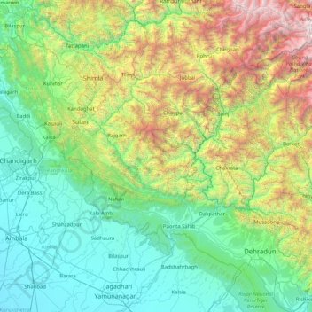
Name: Sirmaur topographic map, elevation, terrain.
Location: Sirmaur, Himachal Pradesh, India (30.05000 76.80000 31.45000 78.20000)
Average elevation: 1,311 m
Minimum elevation: 252 m
Maximum elevation: 5,456 m
Other topographic maps
Click on a map to view its topography, its elevation and its terrain.
Palampur
Palampur, Kangra District, Himachal Pradesh, India
Average elevation: 1,520 m
Talkehr
India > Himachal Pradesh > Jogindarnagar > Ahju
Talkehr, Ahju, Jogindarnagar, Mandi District, Himachal Pradesh, 176077, India
Average elevation: 1,337 m
Pulag
India > Himachal Pradesh > Kullu > Barehigran
Pulag, Barehigran, Kullu, Kullu District, Himachal Pradesh, 175130, India
Average elevation: 2,494 m
Kullu
India > Himachal Pradesh > Kullu
Kullu, Himachal Pradesh, 175100, India
Average elevation: 1,808 m
Waknaghat
India > Himachal Pradesh > Waknaghat
Waknaghat, Solan, Himachal Pradesh, India
Average elevation: 1,557 m
Lahul and Spiti
Lahul and Spiti, Himachal Pradesh, India
Average elevation: 4,286 m