
Make a donation
Andhra Pradesh topographic map
Click on the map to display elevation.
Make a donation
Andhra Pradesh
There are three A1 and 23 A-category railway stations in the state, as per the assessment in 2017. Visakhapatnam has been declared the cleanest railway station in the country, as per the assessment in 2018. The railway station in Shimiliguda was the first highest broad gauge railway station in the country in terms of altitude.
Make a donation
About this map
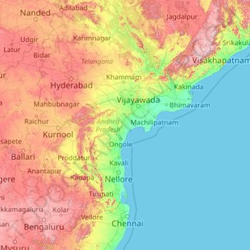
Name: Andhra Pradesh topographic map, elevation, terrain.
Location: Andhra Pradesh, India (12.62272 76.76113 19.16633 84.76474)
Average elevation: 269 m
Minimum elevation: -1 m
Maximum elevation: 1,463 m
Make a donation
Other topographic maps
Click on a map to view its topography, its elevation and its terrain.
Polavaram Project Left Channel
India > Andhra Pradesh > Nakkapalle > Sitampalem
Average elevation: 42 m
Chennai
Chennai is located on the southeastern coast of India in the northeastern part of Tamil Nadu on a flat coastal plain known as the Eastern Coastal Plains with an average elevation of 6.7 m (22 ft) and highest point at 60 m (200 ft). Chennai's soil is mostly clay, shale and sandstone. Clay underlies most of the…
Average elevation: 7 m
Make a donation
Ankola
India > Karnataka > Ankola taluk
Ankola is located at 14°39′38″N 74°18′17″E / 14.66056°N 74.30472°E / 14.66056; 74.30472. It has an average elevation of 17 metres (56 ft). The Gangavali River (also known as Bedti) is a prominent river that flows near the town. Summer temperatures range between 30 and 35 °C (86 and 95…
Average elevation: 27 m
Make a donation
Bengaluru
India > Karnataka > Bangalore North
Bangalore (/ˈbæŋɡəlɔːr, ˌbæŋɡəˈlɔːr/ BANG-gə-lor, -LOR), officially Bengaluru (Kannada pronunciation: [ˈbeŋgɐɭuːɾu] ; ISO: Beṁgaḷūru), is the capital and largest city of the southern Indian state of Karnataka. It has a population of more than 8 million and a metropolitan…
Average elevation: 879 m
Make a donation
Ichalkaranji
India > Maharashtra > Hatkanangle
Ichalkaranji is located at 16°42′N 74°28′E / 16.7°N 74.47°E / 16.7; 74.47. It has an average elevation of 538 metres (1768 ft).
Average elevation: 562 m
Make a donation
Make a donation
Itanagar
India > Arunachal Pradesh > Itanagar EAC
Itanagar is located at 27°06′N 93°37′E / 27.1°N 93.62°E / 27.1; 93.62. It has an average elevation of 320 metres.
Average elevation: 539 m
Puducherry
India > Puducherry > Puducherry Taluk
The topography of Pondicherry is the same as that of coastal Tamil Nadu. Pondicherry's average elevation is at sea level and includes a number of sea inlets, referred to locally as "backwaters". Pondicherry experiences extreme coastal erosion as a result of a breakwater constructed in 1989, just to the south…
Average elevation: 10 m
Make a donation
Udupi
India > Karnataka > Udupi taluku
Udupi has an elevation of 27 m (89 ft) above mean sea level. The climate in Udupi is hot in summers and pleasant in winter. During summers (from March to May) the temperature reaches up to 38 °C (100 °F) and in winters (from December to February) it is usually between 32 and 20 °C (90 and 68 °F). As it is…
Average elevation: 17 m
Make a donation
Sirsi
India > Karnataka > Shirasi Taluk
Sirsi is located at 14°37′N 74°51′E / 14.62°N 74.85°E / 14.62; 74.85 (Grid Square MK74). It has an elevation ranging between 1860 feet to 2600 feet above sea level, and is situated in the heart of the Western Ghats. Sirsi is about 399 kilometres (248 mi) from Bangalore. The nearest airport is…
Average elevation: 556 m
Make a donation
Roorkee
India > Uttarakhand > Roorkee
Roorkee is located at 29°52′N 77°53′E / 29.87°N 77.88°E / 29.87; 77.88. It has an average elevation of 268 metres (879 ft).
Average elevation: 270 m
Guna
India > Madhya Pradesh > Guna NagarTahsil
Guna is located at 24°39′N 77°19′E / 24.65°N 77.32°E / 24.65; 77.32. It has an average elevation of 474 metres (1555 ft).
Average elevation: 474 m
Make a donation
Leh
India > Ladakh > Leh Tehsil
Leh (/ˈleɪ/) is a city in Indian-administered Ladakh in the disputed Kashmir region. It is the largest city and the joint capital of Ladakh. Leh, located in the Leh district, was also the historical capital of the Kingdom of Ladakh. The seat of the kingdom, Leh Palace, the former residence of the royal…
Average elevation: 3,653 m
Jamshedpur
India > Jharkhand > Golmuri-Cum-Jugsalai
Jamshedpur is situated in the southern end of the state of Jharkhand and is bordered by the states of Odisha and West Bengal. The average elevation of the city is 135 metres while the range is from 129 m to 151 m. Total geographical area of Jamshedpur is 224 km square. Jamshedpur is primarily located in a…
Average elevation: 195 m
Make a donation
Mount Abu
India > Rajasthan > Abu Road Tehsil
Mount Abu town, the only hill station in Rajasthan, is at an elevation of 1,220 m (4,003 ft). It has been a popular retreat from the heat of Rajasthan and neighboring Gujarat for centuries.
Average elevation: 914 m
Bhubaneshwar
India > Odisha > Bhubaneswar (M.Corp.)
Bhubaneswar is in Khordha district of Odisha. It is in the eastern coastal plains, along the axis of the Eastern Ghats mountains. The city has an average altitude of 45 m (148 ft) above sea level. It lies southwest of the Mahanadi River that forms the northern boundary of Bhubaneswar metropolitan area, within…
Average elevation: 30 m
Make a donation
Bagalkote
India > Karnataka > Bagalakote taluk
Bagalakote, is a city in the state of Karnataka, India, which is also the headquarters of Bagalakote district. It is situated on branch of River Ghataprabha about 481 km (299 mi) northwest of state capital Bengaluru, 410 km (255 mi) southwest of Hyderabad, and about 570 km (354 mi) southeast of Mumbai. The…
Average elevation: 556 m
Make a donation
Make a donation
Make a donation