
Bali topographic map
Interactive map
Click on the map to display elevation.
About this map
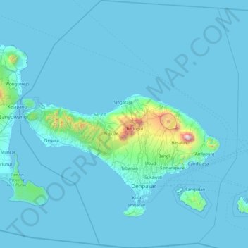
Name: Bali topographic map, elevation, terrain.
Location: Bali, Lesser Sunda Islands, Indonesia (-9.05023 114.41268 -7.46280 115.83242)
Average elevation: 88 m
Minimum elevation: -1 m
Maximum elevation: 2,917 m
Bali's central mountains include several peaks over 2,000 metres (6,600 feet) in elevation and active volcanoes such as Mount Batur. The highest is Mount Agung (3,031 m; 9,944 ft), known as the "mother mountain", which is an active volcano rated as one of the world's most likely sites for a massive eruption within the next 100 years. In late 2017 Mount Agung started erupting and large numbers of people were evacuated, temporarily closing the island's airport. Mountains range from centre to the eastern side, with Mount Agung the easternmost peak. Bali's volcanic nature has contributed to its exceptional fertility and its tall mountain ranges provide the high rainfall that supports the highly productive agriculture sector. South of the mountains is a broad, steadily descending area where most of Bali's large rice crop is grown. The northern side of the mountains slopes more steeply to the sea and is the main coffee-producing area of the island, along with rice, vegetables, and cattle. The longest river, Ayung River, flows approximately 75 km (47 mi) (see List of rivers of Bali).
Other topographic maps
Click on a map to view its topography, its elevation and its terrain.
Balanti
Indonesia > West Sulawesi > Pasangkayu
Balanti, Pasangkayu, West Sulawesi, Sulawesi, Indonesia
Average elevation: 20 m
Tarnate
Indonesia > Central Sulawesi > Parigi Moutong Regency
Tarnate, Parigi Moutong Regency, Central Sulawesi, Sulawesi, Indonesia
Average elevation: 12 m
Dukono
Indonesia > North Maluku > Halmahera Utara
Dukono, Halmahera Utara, North Maluku, Maluku, Indonesia
Average elevation: 1,033 m
Mount Ibu
Indonesia > North Maluku > Halmahera Barat
Mount Ibu, Halmahera Barat, North Maluku, Maluku, Indonesia
Average elevation: 951 m
Lokon-Empung
Indonesia > North Sulawesi > Tomohon
Lokon-Empung, Tomohon, North Sulawesi, Sulawesi, 95415, Indonesia
Average elevation: 1,096 m
Kentur Tetempangan
Kentur Tetempangan, Minahasa, North Sulawesi, Sulawesi, Indonesia
Average elevation: 1,084 m
Sabu Raijua
Indonesia > East Nusa Tenggara
Sabu Raijua, East Nusa Tenggara, Lesser Sunda Islands, Indonesia
Average elevation: 6 m
Tabang
Tabang, Talaud Islands, North Sulawesi, Sulawesi, Indonesia
Average elevation: 143 m
Merauke
Merauke, South Papua, Western New Guinea, Indonesia
Average elevation: 11 m
Bitin
Indonesia > South Kalimantan > Hulu Sungai Utara
Bitin, Hulu Sungai Utara, South Kalimantan, Kalimantan, Indonesia
Average elevation: 5 m
Kutai Kartanegara
Kutai Kartanegara, East Kalimantan, Kalimantan, Indonesia
Average elevation: 217 m
Tomado
Tomado, Sigi Regency, Central Sulawesi, Sulawesi, Indonesia
Average elevation: 1,064 m
Kota Baru
Indonesia > South Sumatra > Penukal Abab Lematang Ilir
Kota Baru, Penukal Utara, Penukal Abab Lematang Ilir, South Sumatra, Sumatra, Indonesia
Average elevation: 44 m
East Nusa Tenggara
East Nusa Tenggara, Lesser Sunda Islands, Indonesia
Average elevation: 31 m
Mount Marapi
Indonesia > West Sumatra > Agam
Mount Marapi, Agam, West Sumatra, Sumatra, Indonesia
Average elevation: 2,457 m
Special Region of Yogyakarta
Special Region of Yogyakarta, Java, Indonesia
Average elevation: 141 m
Pulau Halmahera
Indonesia > Special Capital Region of Jakarta
Pulau Halmahera, Taman Mini Indonesia Indah (TMII), Cipayung, East Jakarta, Special Capital Region of Jakarta, Java, Indonesia
Average elevation: 38 m
Sanggau
Sanggau, West Kalimantan, Kalimantan, Indonesia
Average elevation: 106 m
Jayawijaya
Jayawijaya, Highland Papua, Western New Guinea, Indonesia
Average elevation: 2,469 m
West Nusa Tenggara
West Nusa Tenggara, Lesser Sunda Islands, Indonesia
Average elevation: 45 m
Nuamuri
Indonesia > East Nusa Tenggara > Ende
Nuamuri, Ende, East Nusa Tenggara, Lesser Sunda Islands, Indonesia
Average elevation: 990 m
Mamasa
Mamasa, West Sulawesi, Sulawesi, 91362, Indonesia
Average elevation: 1,152 m
Ngemplak
Indonesia > Central Java > Boyolali > Desa Sawahan
Ngemplak, Desa Sawahan, Kecamatan Ngemplak, Boyolali, Central Java, Java, 57171, Indonesia
Average elevation: 115 m
Kota Baru
Indonesia > North Maluku > Ternate
Kota Baru, Ternate, North Maluku, Maluku, 97714, Indonesia
Average elevation: 44 m
Los
Indonesia > Southwest Papua > Raja Ampat
Los, Raja Ampat, Southwest Papua, Western New Guinea, Indonesia
Average elevation: 28 m
Yogyakarta
Indonesia > Special Region of Yogyakarta
Yogyakarta, Special Region of Yogyakarta, Java, Indonesia
Average elevation: 157 m
Seruyan
Indonesia > Central Kalimantan
Seruyan, Central Kalimantan, Kalimantan, Indonesia
Average elevation: 82 m
Sikatan
Indonesia > Central Java > Jepara > Bondo
Sikatan, Bondo, Jepara, Central Java, Java, 59452, Indonesia
Average elevation: 26 m
Ili Boleng
Indonesia > East Nusa Tenggara > Flores Timur
Ili Boleng, Flores Timur, East Nusa Tenggara, Lesser Sunda Islands, Indonesia
Average elevation: 1,080 m
Leroboleng
Indonesia > East Nusa Tenggara > Flores Timur > Blepanawa
Leroboleng, Blepanawa, Flores Timur, East Nusa Tenggara, Lesser Sunda Islands, Indonesia
Average elevation: 796 m