
Bogor topographic map
Click on the map to display elevation.
Bogor
The city is situated in the western part of Java island, about 53 km south of the capital Jakarta and 85 km northwest of Bandung, the administrative center of West Java Province. Bogor spreads over a basin near volcanoes Salak, which peaks at about 12 km south, and Mount Gede whose top is 22–25 km south-east of the city. The average elevation is 265 meters, maximum 330 m, and minimum 190 meters above sea level. The terrain is rather uneven: 17.64 km2 of its area has slopes of 0–2°, 80.9 km2 from 2° to 15°, 11 km2 between 15° and 25°, 7.65 km2 from 25° to 40° and 1.20 km2 over 40°; the northern part is relatively flat and the southern part is more hilly.
About this map
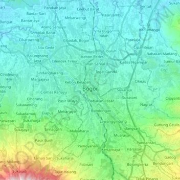
Name: Bogor topographic map, elevation, terrain.
Location: Bogor, West Java, Java, Indonesia (-6.68131 106.73484 -6.51433 106.84856)
Average elevation: 310 m
Minimum elevation: 129 m
Maximum elevation: 1,145 m
Other topographic maps
Click on a map to view its topography, its elevation and its terrain.
Bandung
Indonesia > West Java > Bandung
Bandung, the capital of West Java province, located about 180 kilometres (110 mi) southeast of Jakarta, is the third-largest city in Indonesia. Its elevation is 768 metres (2,520 ft) above sea level and is surrounded by up to 2,400 metres (7,900 feet) high Late Tertiary and Quaternary volcanic terrain. The 400…
Average elevation: 879 m
Telagabodas
Mount Talagabodas or Mount Telagabodas (which means Mount of White Lake (refer to white crater lake) in Sundanese) is a stratovolcano in West Java, Indonesia. The volcano is about 25 km to the east of the town of Garut and is built up of andesitic lavas and pyroclastics. Fumaroles, mud pots and hot springs are…
Average elevation: 1,735 m