
Cyprus topographic map
Interactive map
Click on the map to display elevation.
About this map
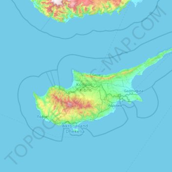
Name: Cyprus topographic map, elevation, terrain.
Location: Cyprus (34.43837 32.02276 35.91325 34.85532)
Average elevation: 73 m
Minimum elevation: -5 m
Maximum elevation: 2,247 m
The physical relief of the island is dominated by two mountain ranges, the Troodos Mountains and the smaller Kyrenia Range, and the central plain they encompass, the Mesaoria. The Mesaoria plain is drained by the Pedieos River, the longest on the island. The Troodos Mountains cover most of the southern and western portions of the island and account for roughly half its area. The highest point on Cyprus is Mount Olympus at 1,952 m (6,404 ft), located in the centre of the Troodos range. The narrow Kyrenia Range, extending along the northern coastline, occupies substantially less area, and elevations are lower, reaching a maximum of 1,024 m (3,360 ft). The island lies within the Anatolian Plate.
Other topographic maps
Click on a map to view its topography, its elevation and its terrain.
Philippines
Philippines
Average elevation: 33 m
Boise
United States of America > Idaho > Boise
Boise, Ada County, Idaho, 83702, United States of America
Average elevation: 1,040 m
Dasmarinas
Philippines > Cavite > Dasmarinas > Buhi
Dasmarinas, Cavite, Calabarzon, 4114, Philippines
Average elevation: 114 m
Mandaluyong
Mandaluyong, Eastern Manila District, Metro Manila, 1551, Philippines
Average elevation: 33 m
Suffolk County
Suffolk County, New York, United States
Average elevation: 34 m
Tuguegarao
Tuguegarao, Cagayan, Cagayan Valley, 3500, Philippines
Average elevation: 49 m
Zamboanga City
Philippines > Zamboanga Peninsula > Zamboanga City
Zamboanga City, Zamboanga Peninsula, 7000, Philippines
Average elevation: 83 m
Cebu City
Philippines > Cebu > Cebu City
Cebu City, Cebu, Central Visayas, 6000, Philippines
Average elevation: 140 m
Donnelly
United States > Idaho > Valley County
Donnelly, Valley County, Idaho, United States
Average elevation: 1,483 m
Taal Volcano
Philippines > Batangas > San Nicolas
Taal Volcano, San Nicolas, Batangas, Calabarzon, 4207, Philippines
Average elevation: 91 m
Samal Island
Philippines > Davao del Norte > Samal
Samal Island, Samal, Island Garden City of Samal, Davao del Norte, Davao Region, 8119, Philippines
Average elevation: 117 m
Sorsogon City
Sorsogon City, Sorsogon, Bicol Region, 4700, Philippines
Average elevation: 89 m
Quezon City
Quezon City, Eastern Manila District, Metro Manila, Philippines
Average elevation: 57 m
Red Bull Ring
Red Bull Ring, Spielberg, Murtal, Styria, 824, Austria
Average elevation: 755 m
Batangas City
Batangas City, Batangas, Calabarzon, 4200, Philippines
Average elevation: 65 m
Mahabangkahoy Lejos
Philippines > Cavite > Indang
Mahabangkahoy Lejos, Indang, Cavite, Calabarzon, 4122, Philippines
Average elevation: 465 m
Santa Rosa
Philippines > Laguna > Santa Rosa
Santa Rosa, Laguna, Calabarzon, 4026, Philippines
Average elevation: 65 m
San Pablo
Philippines > Laguna > San Pablo
San Pablo, Laguna, Calabarzon, 4000, Philippines
Average elevation: 220 m
Malolos
Malolos, Bulacan, Central Luzon, 3000, Philippines
Average elevation: 6 m
Rosario Heights XI
Rosario Heights XI, Cotabato City, Bangsamoro, 9600, Philippines
Average elevation: 5 m
Greenville
United States > South Carolina > Greenville County
Greenville, Greenville County, South Carolina, United States
Average elevation: 290 m
Elbasan
Albania > Central Albania > Elbasan County
Elbasan, Elbasan Municipality, Elbasan County, Central Albania, Albania
Average elevation: 164 m
Babo Sacan
Philippines > Pampanga > Porac
Babo Sacan, Porac, Pampanga, Central Luzon, 2008, Philippines
Average elevation: 81 m
Maligaya
Philippines > Agusan del Sur > Rosario
Maligaya, Rosario, Agusan del Sur, Caraga, Philippines
Average elevation: 78 m
Kibid
Philippines > South Cotabato > Norala
Kibid, Norala, South Cotabato, Soccsksargen, 9508, Philippines
Average elevation: 98 m
Lanas
Philippines > Romblon > San Jose
Lanas, San Jose, Romblon, Mimaropa, 5510, Philippines
Average elevation: 35 m
Perez
Philippines > Laguna > Calauan
Perez, Calauan, Laguna, Calabarzon, 4012, Philippines
Average elevation: 82 m
Baguio
Baguio, Cordillera Administrative Region, 2600, Philippines
Average elevation: 1,371 m
Simms Landing
United States > Maryland > Charles County
Simms Landing, Charles County, Maryland, 20677, United States
Average elevation: 26 m
Bayasong
Philippines > Sorsogon > Pilar
Bayasong, Pilar, Sorsogon, Bicol Region, 4714, Philippines
Average elevation: 32 m
Catubig
Catubig, Northern Samar, Eastern Visayas, Philippines
Average elevation: 41 m
Old Bulatukan
Philippines > North Cotabato > Makilala
Old Bulatukan, Makilala, North Cotabato, Soccsksargen, 9401, Philippines
Average elevation: 560 m
Alfonso
Philippines > Cavite > Alfonso
Alfonso, Cavite, Calabarzon, 4123, Philippines
Average elevation: 413 m