
Philippines topographic map
Click on the map to display elevation.
Philippines
The Philippines is an archipelago of approximately 7,641 islands, with a total land area of about 300,000 square kilometers. The terrain is predominantly mountainous, with narrow coastal plains and valleys. The highest peak is Mount Apo on Mindanao, reaching 2,954 meters (9,692 feet) above sea level. Other notable mountains include Mount Pulag in Luzon and Mount Dulang-Dulang in Mindanao. The Sierra Madre mountain range, the longest in the Philippines, stretches along the eastern side of Luzon. The country is also home to several active volcanoes, such as Mayon, Taal, and Canlaon, contributing to its varied topography. The extensive coastline, measuring 36,289 kilometers (22,549 miles), features numerous bays, coves, and inlets, with Manila Bay being one of the finest harbors in East Asia. The Philippines' diverse landscape includes fertile plains like the Central Luzon plains, known as the "Rice Bowl of the Philippines," and the Cagayan Valley, which is the country's longest river system. The varied terrain has led to a rich biodiversity, with tropical rainforests providing habitats for numerous species. The country's location along the Pacific Ring of Fire makes it prone to earthquakes and volcanic activity, further shaping its dynamic landscape.
About this map
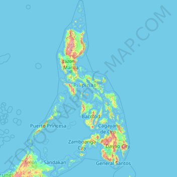
Name: Philippines topographic map, elevation, terrain.
Location: Philippines (4.38333 114.10037 21.32193 126.80308)
Average elevation: 33 m
Minimum elevation: -1 m
Maximum elevation: 2,639 m
Other topographic maps
Click on a map to view its topography, its elevation and its terrain.
Polavaram Project Left Channel
India > Andhra Pradesh > Nakkapalle > Sitampalem
Average elevation: 42 m
San Juan
"San Juan" is a contraction of the city's traditional name of "San Juan del Monte" (lit. 'Saint John of the Mountain'). As with numerous other places in the Philippines, the name combines a patron saint and a toponym; in this case Saint John the Baptist with the locale's hilly terrain and relatively higher…
Average elevation: 35 m
Vigan
Vigan is situated in a Quaternary Age sedimentary plain called the Vigan-Bantay Plain which is part of the Ilocos coastal plain. The Vigan-Bantay Plain is bounded on the east by a moderately rugged Miocene sediments consisting of interbedded sandstones and shale to very rugged Meta-volcanics and Meta sediment…
Average elevation: 63 m
Bacolod
Bacólod (English: Bacolod), is derived from bakólod (Old Spelling: bacólod), the Old Hiligaynon (Old Ilonggo) (Old Spelling: Ylongo and Ilongo) word for a "hill, turtle, mound, rise, hillock, down, any small eminence or elevation", since the resettlement was founded on a stony, hilly area, now the barangay…
Average elevation: 49 m
Baguio
In 1903, Filipinos, Japanese and Chinese workers were hired to build Kennon Road, the first road directly connecting Baguio with the lowlands of La Union and Pangasinan. Before this, the only road to Benguet was Naguilian Road, and it was largely a horse trail at higher elevations. Camp John Hay was…
Average elevation: 881 m
Malolos
Malolos is relatively flat of about 0.81% to a gently sloping of 2.17%. The slope of the land descends towards west, southwest to southern direction. The highest land elevation is at about 6.0 meters above sea level while the lowest is only half a meter below sea level. A network of natural waterways and…
Average elevation: 6 m
Quezon City
Founded as a pueblo by Saint Pedro Bautista in 1590, San Francisco del Monte may be considered Quezon City's oldest district. The original land area of the old town of San Francisco del Monte was approximately2.5 square kilometres (1.0 sq mi) and covered parts of what is currently known as Project 7 and 8 and…
Average elevation: 57 m
Tabaco
The City of Tabaco is located on the eastern coast of Albay province with an area of 117.14 km2 (45.23 sq mi). The terrain in the poblacion or town center of Tabaco is generally flat with the highest elevation at around 5 m (16 ft). The northwestern portion reaches 400 m (1,300 ft) above sea level. The city's…
Average elevation: 182 m
San Marcelino
In 1843, the Marcelinians filed a petition for San Marcelino's elevation to Pueblo through the Teniente Primero, Antonio Ladrido Juliano. In 1846, the petition was approved.
Average elevation: 45 m
Mandaluyong
Another claims that the Spaniards named the place based on the report of a navigator named Acapulco, who saw the rolling hills frequently being lashed at by daluyong (“big waves from the sea”). This seems to confirm traditional pre-Hispanic stories that giant waves from the sea would meet the adjoining…
Average elevation: 33 m
Valenzuela
The highest elevation point is 38 meters (125 ft) above sea level. Having a surface gradient of 0.55% and a gentle slope, hilly landscape is located in the industrial section of the city in Canumay. The average elevation point is 2 meters (6.6 ft) above sea level.
Average elevation: 24 m
Mandaue
It is one of the two (the other one being the municipality of Consolacion) local government units located within the mainland Metro Cebu where the elevation of land is less than 100 m (330 ft).
Average elevation: 109 m
Trece Martires
The city of Trece Martires is characterised with ground elevation ranging from 30m to nearly 400m. Its ground slope ranges from 0.5 to 2%.
Average elevation: 150 m