
Make a donation
Batangas City topographic map
Click on the map to display elevation.
Make a donation
Batangas City
The city is the center of the radio listening market in Batangas, and is served by local radio stations, as well as some radio stations from Lipa and other parts of the Mega Manila area. The Roman Catholic Archdiocese of Lipa, through the Radyo Bayanihan System, hosts two local radio stations: ALFM 95.9 Radyo Totoo (DWAL), a religion, news, talk, and music-oriented station, and 99.1 Spirit FM (DWAM), a religion and music-oriented station. Other radio stations include 91.9 Air1 Radio Southern Tagalog (DWCH), an adult contemporary-oriented station, 99.9 GV FM (DZGV), a contemporary hit radio station, and 104.7 Brigada News FM (DWEY), an FM news radio station. Batangas State University hosts a college radio station, 107.3 BatStateU FM (DWPB-FM). Signals from other stations in Metro Manila are not clearly received because of the local topography.
Make a donation
About this map
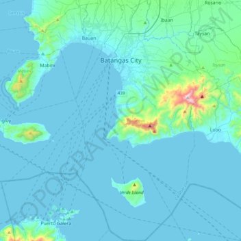
Name: Batangas City topographic map, elevation, terrain.
Location: Batangas City, Batangas, Calabarzon, 4200, Philippines (13.47385 120.98567 13.84918 121.19090)
Average elevation: 65 m
Minimum elevation: -1 m
Maximum elevation: 944 m
Make a donation
Other topographic maps
Click on a map to view its topography, its elevation and its terrain.
Make a donation
Make a donation
Make a donation
Taal Volcano
Philippines > Batangas > San Nicolas
Volcano Island sank from 1 to 3 m (3 to 10 ft) as a result of the eruption. It was also found that the southern shore of Lake Taal sank in elevation from the eruption. No evidences of lava could be discovered anywhere, nor have geologists been able to trace any visible records of a lava flow having occurred at…
Average elevation: 91 m
Make a donation
Make a donation
Make a donation
Make a donation
Make a donation
Make a donation
Make a donation
Make a donation
Make a donation
Make a donation
Make a donation
Make a donation
Make a donation
Make a donation
Make a donation
Make a donation
Batangas City
Philippines > Batangas > Batangas City > Batangas City
The city is the center of the radio listening market in Batangas, and is served by local radio stations, as well as some radio stations from Lipa and other parts of the Mega Manila area. The Roman Catholic Archdiocese of Lipa, through the Radyo Bayanihan System, hosts two local radio stations: ALFM 95.9 Radyo…
Average elevation: 108 m
Make a donation
Make a donation
Make a donation
Make a donation
Make a donation
Make a donation