
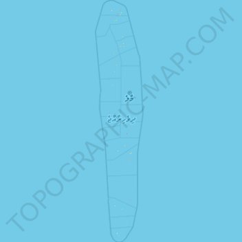
Maldives topographic map
Interactive map
Click on the map to display elevation.
About this map
Name: Maldives topographic map, elevation, terrain.
Location: Maldives (-0.90749 72.35542 7.31062 73.97010)
Average elevation: 0 m
Minimum elevation: 0 m
Maximum elevation: 11 m
The Maldives is the smallest country in Asia. Including the sea, the territory spans roughly 90,000 square kilometres (35,000 sq mi), and a land area of 298 square kilometres (115 sq mi). The Maldives is one of the world's most geographically dispersed sovereign states, and the smallest Muslim-majority country by land area. With a population of 515,132 in the 2022 census, it is the 2nd least populous country in Asia. Malé is the capital and the most populated city, traditionally called the "King's Island", where the ancient royal dynasties ruled from its central location. The Maldivian Archipelago is located on the Chagos–Laccadive Ridge, a vast submarine mountain range in the Indian Ocean; this also forms a terrestrial ecoregion with the Chagos Archipelago and Lakshadweep. The Maldives has an average ground-level elevation of 1.5 metres (4 ft 11 in) above sea level, and a highest natural point of only 2.4 metres (7 ft 10 in), making it the world's lowest-lying country. Some sources state the highest point, Mount Villingili, as 5.1 metres or 17 feet.
Other topographic maps
Click on a map to view its topography, its elevation and its terrain.
Philippines
Philippines
Average elevation: 33 m
Davao City
Philippines > Davao Occidental > Davao City
Davao City, Davao Region, Philippines
Average elevation: 303 m
Cebu City
Philippines > Cebu > Cebu City
Cebu City, Cebu, Central Visayas, 6000, Philippines
Average elevation: 140 m
Nellis Air Force Base
United States > Nevada > Clark County
Nellis Air Force Base, Clark County, Nevada, 89115, United States
Average elevation: 576 m
Grass Valley
United States > Nevada > Humboldt County
Grass Valley, Humboldt County, Nevada, United States
Average elevation: 1,329 m
Niles
United States > Ohio > Trumbull County > Weathersfield Township
Niles, Weathersfield Township, Trumbull County, Ohio, 44446, United States
Average elevation: 280 m
Suffolk County
Suffolk County, New York, United States
Average elevation: 34 m
Sorsogon City
Sorsogon City, Sorsogon, Bicol Region, 4700, Philippines
Average elevation: 89 m
Tuguegarao
Tuguegarao, Cagayan, Cagayan Valley, 3500, Philippines
Average elevation: 49 m
P-4 Panag
Philippines > Davao de Oro > New Bataan > Panag
P-4 Panag, Panag, New Bataan, Davao de Oro, Davao Region, Philippines
Average elevation: 100 m
Lake Lahit
Lake Lahit, South Cotabato, Soccsksargen, 9514, Philippines
Average elevation: 611 m
Pasig River
Pasig River, Namayan, District I, Mandaluyong, Eastern Manila District, Metro Manila, 1009, Philippines
Average elevation: 8 m
Baguio
Baguio, Cordillera Administrative Region, 2600, Philippines
Average elevation: 1,371 m
Laguna de Bay
Laguna de Bay, Southern Manila District, Laguna, Calabarzon, Philippines
Average elevation: 62 m
Boise
United States of America > Idaho > Boise
Boise, Ada County, Idaho, 83702, United States of America
Average elevation: 1,040 m
Taal Volcano
Philippines > Batangas > San Nicolas
Taal Volcano, San Nicolas, Batangas, Calabarzon, 4207, Philippines
Average elevation: 91 m
Batangas City
Batangas City, Batangas, Calabarzon, 4200, Philippines
Average elevation: 65 m
Bansud
Philippines > Oriental Mindoro
Bansud, Oriental Mindoro, Mimaropa, Philippines
Average elevation: 20 m
The Archipelago Township
Canada > Ontario > Parry Sound District
The Archipelago Township, Parry Sound District, Central Ontario, Ontario, Canada
Average elevation: 204 m
Dasmarinas
Philippines > Cavite > Dasmarinas > Buhi
Dasmarinas, Cavite, Calabarzon, 4114, Philippines
Average elevation: 114 m
Rizal
Philippines > Quirino > Rizal
Rizal, Quirino, Cagayan Valley, Philippines
Average elevation: 130 m
Malolos
Malolos, Bulacan, Central Luzon, 3000, Philippines
Average elevation: 6 m
Mandaluyong
Mandaluyong, Eastern Manila District, Metro Manila, 1551, Philippines
Average elevation: 33 m
Quezon City
Quezon City, Eastern Manila District, Metro Manila, Philippines
Average elevation: 57 m
Réservoir sous-terrain
Réservoir sous-terrain, Mirabel, Laurentides, Quebec, Canada
Average elevation: 68 m
Graciano Lopez Jaena Park
Philippines > Iloilo City > Jaro
Graciano Lopez Jaena Park, Cuartero, Jaro, Iloilo City, Western Visayas, 5000, Philippines
Average elevation: 8 m
Balangcas
Philippines > Pampanga > Minalin
Balangcas, Minalin, Pampanga, Central Luzon, Philippines
Average elevation: 3 m
Kibawe
Kibawe, Bukidnon, Northern Mindanao, 8720, Philippines
Average elevation: 267 m
Akle
Indonesia > East Nusa Tenggara > Kupang
Akle, Kupang, East Nusa Tenggara, Lesser Sunda Islands, Indonesia
Average elevation: 18 m
Santa Ana
United States > California > Orange County
Santa Ana, Orange County, California, United States
Average elevation: 30 m
Calama
Chile > Antofagasta Region > Provincia de El Loa
Calama, Provincia de El Loa, Antofagasta Region, 1395584, Chile
Average elevation: 2,653 m
Balindong
Balindong, Lanao del Sur, Bangsamoro, 9318, Philippines
Average elevation: 822 m