
Laguna de Bay topographic map
Interactive map
Click on the map to display elevation.
Laguna de Bay
Laguna de Bay (Spanish for "Lagoon/Lake of Bay"; Tagalog: Lawa ng Bay, [baɪ]), also known as Laguna Lake, is the largest lake in the Philippines. It is located southeast of Metro Manila, between the provinces of Laguna to the south and Rizal to the north. A freshwater lake, it has a surface area of 911–949 km² (352–366 sq mi), with an average depth of about 2.8 meters (9 ft 2 in) and an elevation of about one meter above sea level. The lake is shaped like a crow's foot, with two peninsulas jutting out from the northern shore and filling the large volcanic Laguna Caldera. In the middle of the lake is the large island of Talim.
About this map
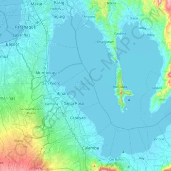
Name: Laguna de Bay topographic map, elevation, terrain.
Average elevation: 62 m
Minimum elevation: -3 m
Maximum elevation: 706 m
Other topographic maps
Click on a map to view its topography, its elevation and its terrain.
Mount San Cristobal
Philippines > Laguna > Rizal
Mount San Cristobal is a potentially active stratovolcano at the boundary of the provinces of Laguna and Quezon on the island of Luzon, Philippines. The mountain rises to an elevation of 1,470 m (4,820 ft) above mean sea level and is one of the volcanic features of Macolod Corridor.
Average elevation: 1,021 m
Mount Makiling
Philippines > Laguna > Los Baños
Mount Makiling (also spelled Maquiling) is an inactive stratovolcano located in the provinces of Laguna and Batangas on the island of Luzon in the Philippines. The mountain rises to an elevation of 1,090 meters (3,580 ft) above mean sea level and is the highest feature of the Laguna Volcanic Field. The volcano…
Average elevation: 753 m