
North Brabant topographic map
Interactive map
Click on the map to display elevation.
About this map
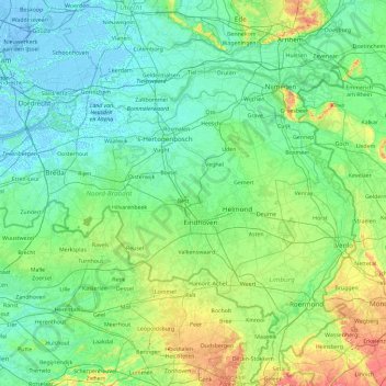
Name: North Brabant topographic map, elevation, terrain.
Location: North Brabant, Netherlands (51.22091 4.19012 51.83075 6.04812)
Average elevation: 22 m
Minimum elevation: -7 m
Maximum elevation: 158 m
The historical region of Kempen occupies the southern part of the province of Noord-Brabant and extends south of Eindhoven far into northern Belgium. To the east it reaches as far as the Meuse valley. The surface topography of De Kempen is very uniform. Most of it lies between 5 m (15 ft) and 35 m (115 ft) above sea level. The basement rocks are Cretaceous and Tertiary sediments, which are overlaid by Ice Age gravels and sands carried here by rivers of melt-water from the retreating glaciers. It is a typical area of sandy heathland. The infertile soil is suitable only for undemanding crops such as rye, oats, potatoes and fodder plants; this limits the profitability of agriculture. Until a few decades ago Kempen was a region of heathland and sand drifts with a sparse growth of pines, a few scattered villages subsisting on the poor soil and some small towns; and this is still the pattern in much of the region. In recent years, however, the rapid advance of industry has brought about profound changes in this agricultural region. The origins of this industrial development go back 70–100 years. The main concentrations of industry are along the southern frontier of the Netherlands, e.g., at Eindhoven, Helmond, Tilburg, Breda, 's-Hertogenbosch.
Other topographic maps
Click on a map to view its topography, its elevation and its terrain.
Oostbeer
Netherlands > Zeeland > Philippine
Oostbeer, Philippine, Terneuzen, Zeeland, Netherlands
Average elevation: 1 m
Rottumerplaat
Netherlands > Groningen > Warffum
Rottumerplaat, Warffum, Het Hogeland, Groningen, Netherlands
Average elevation: 0 m
Rottumeroog
Netherlands > Groningen > Warffum
Rottumeroog, Warffum, Het Hogeland, Groningen, Netherlands
Average elevation: 0 m
Wijnbergen
Netherlands > Gelderland > Doetinchem
Wijnbergen, Doetinchem, Gelderland, Netherlands, 7007 CA, Netherlands
Average elevation: 15 m
's-Hertogenbosch
's-Hertogenbosch, North Brabant, Netherlands
Average elevation: 4 m
Capelle aan den IJssel
Capelle aan den IJssel, South Holland, Netherlands
Average elevation: -1 m
Capelle aan den IJssel
Netherlands > South Holland > Capelle aan den IJssel
Capelle aan den IJssel, Rotterdam, South Holland, Netherlands
Average elevation: -1 m
Zeeuws-Vlaanderen
Netherlands > Zeeland > Terneuzen
Zeeuws-Vlaanderen, Terneuzen, Zeeland, Netherlands, 4542RZ, Netherlands
Average elevation: 0 m
Zaanstad
Netherlands > North Holland > Zaanstad
Zaanstad, North Holland, Netherlands
Average elevation: 0 m
Doetinchem
Netherlands > Gelderland > Doetinchem
Doetinchem, Gelderland, Netherlands
Average elevation: 17 m
Het Hogeland
Netherlands > Groningen > Het Hogeland
Het Hogeland, Groningen, Netherlands
Average elevation: 0 m
Gooise Meren
Netherlands > North Holland > Gooise Meren
Gooise Meren, North Holland, Netherlands
Average elevation: 0 m
Rijswijk
Netherlands > South Holland > Rijswijk
Rijswijk, South Holland, Netherlands
Average elevation: 2 m
Veldhoven
Netherlands > North Brabant > Veldhoven
Veldhoven, North Brabant, Netherlands
Average elevation: 23 m
Mill
Netherlands > North Brabant > Mill en Sint Hubert
Mill, Mill en Sint Hubert, North Brabant, Netherlands
Average elevation: 14 m
Velserbroek
Netherlands > North Holland > Velsen
Velserbroek, Velsen, North Holland, Netherlands
Average elevation: 3 m
Park van Luna
Netherlands > North Holland > Heerhugowaard
Park van Luna, Stad van de Zon, Heerhugowaard, North Holland, Netherlands
Average elevation: -2 m
Eindhoven
Netherlands > North Brabant > Eindhoven
Eindhoven, North Brabant, Netherlands
Average elevation: 20 m
Zoetermeer
Netherlands > South Holland > Zoetermeer
Zoetermeer, South Holland, Netherlands
Average elevation: -3 m
Horst aan de Maas
Horst aan de Maas, Limburg, Netherlands
Average elevation: 27 m
Heerhugowaard
Netherlands > North Holland > Heerhugowaard
Heerhugowaard, North Holland, Netherlands
Average elevation: -1 m