
Sint Eustatius topographic map
Interactive map
Click on the map to display elevation.
About this map
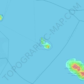
Name: Sint Eustatius topographic map, elevation, terrain.
Location: Sint Eustatius, Netherlands (17.27673 -63.19861 17.72699 -62.78471)
Average elevation: 12 m
Minimum elevation: 0 m
Maximum elevation: 1,044 m
Sint Eustatius is 6 miles (10 km) long and up to 3 miles (5 km) wide. Topographically, the island is saddle-shaped, with the 602-meter-high dormant volcano Quill (Mount Mazinga), (from Dutch kuil, meaning 'pit'—originally referring to its crater) to the southeast and the smaller summits of Signal Hill/Little Mountain (or Bergje) and Boven Mountain to the northwest. The Quill crater is a popular tourist attraction on the island. The bulk of the island's population lives in the flat saddle between the two elevated areas, which forms the centre of the island.
Other topographic maps
Click on a map to view its topography, its elevation and its terrain.
Oostbeer
Netherlands > Zeeland > Philippine
Oostbeer, Philippine, Terneuzen, Zeeland, Netherlands
Average elevation: 1 m
Rottumerplaat
Netherlands > Groningen > Warffum
Rottumerplaat, Warffum, Het Hogeland, Groningen, Netherlands
Average elevation: 0 m
Rottumeroog
Netherlands > Groningen > Warffum
Rottumeroog, Warffum, Het Hogeland, Groningen, Netherlands
Average elevation: 0 m
Wijnbergen
Netherlands > Gelderland > Doetinchem
Wijnbergen, Doetinchem, Gelderland, Netherlands, 7007 CA, Netherlands
Average elevation: 15 m
's-Hertogenbosch
's-Hertogenbosch, North Brabant, Netherlands
Average elevation: 4 m
Capelle aan den IJssel
Capelle aan den IJssel, South Holland, Netherlands
Average elevation: -1 m
Capelle aan den IJssel
Netherlands > South Holland > Capelle aan den IJssel
Capelle aan den IJssel, Rotterdam, South Holland, Netherlands
Average elevation: -1 m
Zeeuws-Vlaanderen
Netherlands > Zeeland > Terneuzen
Zeeuws-Vlaanderen, Terneuzen, Zeeland, Netherlands, 4542RZ, Netherlands
Average elevation: 0 m
Zaanstad
Netherlands > North Holland > Zaanstad
Zaanstad, North Holland, Netherlands
Average elevation: 0 m
Doetinchem
Netherlands > Gelderland > Doetinchem
Doetinchem, Gelderland, Netherlands
Average elevation: 17 m
Het Hogeland
Netherlands > Groningen > Het Hogeland
Het Hogeland, Groningen, Netherlands
Average elevation: 0 m
Gooise Meren
Netherlands > North Holland > Gooise Meren
Gooise Meren, North Holland, Netherlands
Average elevation: 0 m
Rijswijk
Netherlands > South Holland > Rijswijk
Rijswijk, South Holland, Netherlands
Average elevation: 2 m
Veldhoven
Netherlands > North Brabant > Veldhoven
Veldhoven, North Brabant, Netherlands
Average elevation: 23 m
Mill
Netherlands > North Brabant > Mill en Sint Hubert
Mill, Mill en Sint Hubert, North Brabant, Netherlands
Average elevation: 14 m
Velserbroek
Netherlands > North Holland > Velsen
Velserbroek, Velsen, North Holland, Netherlands
Average elevation: 3 m
Park van Luna
Netherlands > North Holland > Heerhugowaard
Park van Luna, Stad van de Zon, Heerhugowaard, North Holland, Netherlands
Average elevation: -2 m
Eindhoven
Netherlands > North Brabant > Eindhoven
Eindhoven, North Brabant, Netherlands
Average elevation: 20 m
Zoetermeer
Netherlands > South Holland > Zoetermeer
Zoetermeer, South Holland, Netherlands
Average elevation: -3 m
Horst aan de Maas
Horst aan de Maas, Limburg, Netherlands
Average elevation: 27 m
Heerhugowaard
Netherlands > North Holland > Heerhugowaard
Heerhugowaard, North Holland, Netherlands
Average elevation: -1 m