
Make a donation
Rincon topographic map
Click on the map to display elevation.
Make a donation
About this map
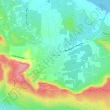
Name: Rincon topographic map, elevation, terrain.
Location: Rincon, Bonaire, Netherlands (12.21867 -68.34982 12.25867 -68.30982)
Average elevation: 40 m
Minimum elevation: 0 m
Maximum elevation: 119 m
Make a donation
Other topographic maps
Click on a map to view its topography, its elevation and its terrain.
Breda
Topographic map image of the city of Breda, March 2014. Click to enlarge.
Average elevation: 7 m
Make a donation
Make a donation
Saba
There is an 8.6 hectares (21 acres) cloud forest located at and above 825 metres (2,707 ft) on top of the mountain referred to as the "Elfin Forest Reserve" because of its high altitude mist and mossy appearance. The most dominant tree in the cloud forest is the Mountain Mahogany (Freziera undulate), although…
Average elevation: 2 m
Make a donation
Capelle aan den IJssel
Dutch Topographic map of the municipality of Capelle aan den IJssel, June 2015.
Average elevation: -1 m
Make a donation