
Guizhou topographic map
Interactive map
Click on the map to display elevation.
About this map
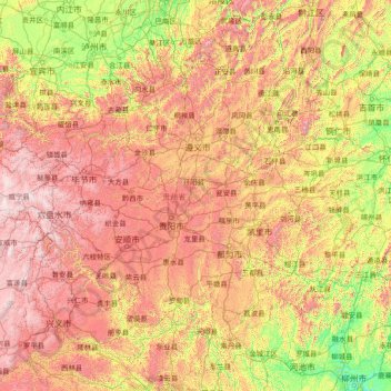
Name: Guizhou topographic map, elevation, terrain.
Location: Guizhou, China (24.62072 103.59999 29.22445 109.59400)
Average elevation: 914 m
Minimum elevation: 68 m
Maximum elevation: 2,813 m
Guizhou is a mountainous province, with its higher altitudes in the west and centre. It lies at the eastern end of the Yungui Plateau. Demographically, it is one of China's most diverse provinces. Minority groups account for more than 37% of the population, including sizable populations of the Miao, Bouyei, Dong, Tujia and Yi peoples, all of whom speak languages distinct from Chinese. The main language spoken in Guizhou is Southwestern Mandarin, a variety of Mandarin.
Other topographic maps
Click on a map to view its topography, its elevation and its terrain.
Guanxian County
Guanxian County, Liaocheng, Shandong, 252500, China
Average elevation: 41 m
Islands District
Islands District, New Territories, Hong Kong, China
Average elevation: 36 m
Double Island
China > Hong Kong > North District > Tung Wan
Double Island, Tung Wan, North District, New Territories, Hong Kong, China
Average elevation: 12 m
Lanting
China > Jiangxi > Hukou County > Junqiao
Lanting, Junqiao, Hukou County, Jiangxi, China
Average elevation: 23 m
Labo River
China > Sichuan > Litang County > Nabo > Zhazha
Labo River, Zhazha, Nabo, Litang County, Kardze, Sichuan, China
Average elevation: 3,708 m
Fenghuang Mountain
China > Zhejiang > Hangzhou City
Fenghuang Mountain, Hangzhou City, Zhejiang, 310002, China
Average elevation: 44 m
Fenghuang County
Fenghuang County, Xiangxi, Hunan, 416200, China
Average elevation: 497 m
Bao'an District
Bao'an District, Shenzhen, Guangdong Province, 518100, China
Average elevation: 36 m
Kashgar Prefecture
China > Xinjiang > Kashgar City
Kashgar Prefecture, Kashgar City, Kachgar, Xinjiang, 844000, China
Average elevation: 2,275 m
Lian River
China > Jiangxi > Yudu County
Lian River, Yudu County, Ganzhou, Jiangxi, China
Average elevation: 243 m
Golog Tibetan Autonomous Prefecture
China > Qinghai > Gadê County
Golog Tibetan Autonomous Prefecture, Gadê County, Golog, Qinghai, China
Average elevation: 4,340 m
Heihe
China > Heilongjiang > 幸福乡
Heihe, 幸福乡, Aihui District, Heihe City, Heilongjiang, 164300, China
Average elevation: 174 m
Mudanjiang
Mudanjiang, Revitalize the streets, Dong'an District, Mudanjiang City, Heilongjiang, 157000, China
Average elevation: 361 m
Shui Choi Tin Village
China > Hong Kong > Hong Kong Island
Shui Choi Tin Village, Southern District, Hong Kong Island, Hong Kong, China
Average elevation: 94 m
Baotou City
Baotou City, Inner Mongolia, 014000, China
Average elevation: 1,318 m
Chengguan District
Chengguan District, Lhasa, Tibet, 850000, China
Average elevation: 4,325 m