Geolocate

Tibet topographic map

Interactive map

Click on the map to display elevation.

Tibet

The Tibet Autonomous Region is located on the Tibetan Plateau, the highest region on Earth. In northern Tibet elevations reach an average of over 4,572 metres (15,000 ft). Mount Everest is located on Tibet's border with Nepal.

Wikipedia (CC-BY-SA 3.0)

About this map

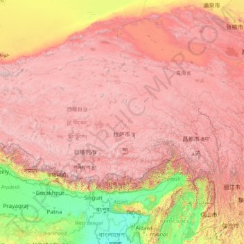
Name: Tibet topographic map, elevation, terrain.

Location: Tibet, China (27.21205 78.39232 36.48407 99.11555)

Average elevation: 3,040 m

Minimum elevation: -1 m

Maximum elevation: 8,096 m

Other topographic maps

Click on a map to view its topography, its elevation and its terrain.

Guyong

China > Fujian > Jiangle County

Average elevation: 264 m

Daong

China > Xinjiang > Fukang City

Average elevation: 3,092 m

Li River

China > Jiangxi > Yihuang County > Lixi

Average elevation: 137 m

Liangan

China > Sichuan > Lezhi County

Average elevation: 448 m

Lawu

China > Sichuan > Litang County

Average elevation: 3,174 m

Dacao

China > Yunnan > Yongsheng County > Lijiang City

Average elevation: 2,232 m

Ngong Ping Village

China > Hong Kong > Islands District

Average elevation: 324 m

Lanting

China > Jiangxi > Hukou County > Junqiao

Average elevation: 23 m

Beijing

China > Beijing

Beijing is situated at the northern tip of the roughly triangular North China Plain, which opens to the south and east of the city. Mountains to the north, northwest and west shield the city and northern China's agricultural heartland from the encroaching desert steppes. The northwestern part of the…

Average elevation: 47 m

Shangchuan

China > Shaanxi > Baoji

Average elevation: 921 m

Labo River

China > Sichuan > Litang County > Nabo > Zhazha

Average elevation: 3,708 m

Tongyu

China > Shanxi > Jinzhong

Average elevation: 1,009 m

Chongqing

China > Chongqing

The central urban area of Chongqing, or Chongqing proper, is a city of unique features. Built on mountains and partially surrounded by the Yangtze and Jialing rivers, it is known as a "mountain city" and a "city on rivers". The night scene of the city is very illuminated, with millions of lights and their…

Average elevation: 318 m

Fenghuang Mountain

China > Zhejiang > Hangzhou City

Average elevation: 44 m

Kashgar Prefecture

China > Xinjiang > Kashgar City

Average elevation: 2,275 m

Mudanjiang

China > Heilongjiang

It also borders Russia's Primorsky Krai to the east. The average elevation in the prefecture is 230 meters (755 ft), with the terrain primarily consisting of mountains and hills. The east of the prefecture begins to ascend to the Changbai Mountains, while the central parts belong to the Hegu Basin. The lowest…

Average elevation: 361 m

Golog Tibetan Autonomous Prefecture

China > Qinghai > Gadê County

The lay of the land of the prefecture is largely determined by the Amne Machin mountain range (max elevation 6,282 m), which runs in the general northwest- to-southeast direction across the entire prefecture, and beyond. The existence of the ridge results in one of the great bends of the Yellow River, which…

Average elevation: 4,340 m

Heihe

China > Heilongjiang > 幸福乡

Average elevation: 174 m

Lian River

China > Jiangxi > Yudu County

Average elevation: 243 m

Nanchang

China > Jiangxi

Average elevation: 65 m

Shibei

China > Shandong

Average elevation: 27 m

Sanjiang

China > Chongqing

Average elevation: 442 m

Zhongshan

China > Guangxi > Zhongshan County

Average elevation: 246 m

汤河

China > Anhui > Chaohu City

Average elevation: 52 m

Chengguan

China > Gansu

Average elevation: 1,484 m

Xinxing

China > Guangdong Province > Xinxing County > Xincheng

Average elevation: 153 m

Tuman

China > Xinjiang > Kashgar City

Average elevation: 1,306 m

Kau To

China > Hong Kong > Sha Tin District

Average elevation: 106 m

Pulong

China > Sichuan

Average elevation: 1,182 m

Gezhouba Dam

China > Hubei > Xiling District

Average elevation: 62 m

Tin Sam

China > Hong Kong > Islands District > Tung Chung > Tin Sam

Average elevation: 70 m

Jianzha

China > Qinghai > Jainca County > Jianzha

Average elevation: 2,681 m

Ligao

China > Guangxi > Tanying Township

Average elevation: 33 m

Datong

China > Shanxi > Datong

Datong is a prefecture-level city in northern Shanxi Province in the People's Republic of China. It is located in the Datong Basin at an elevation of 1,040 metres (3,410 ft) and borders Inner Mongolia to the north and west and Hebei to the east. It had a population of 3,318,057 during the 2010 census, of whom…

Average elevation: 1,149 m

Guyuan

China > Ningxia > Guyuan

Guyuan has a monsoon-influenced humid continental climate (Köppen Dwb), with long, cold, dry winters, and warm, rainier summers. With temperatures cooled by the elevation that exceeds 1,770 metres (5,810 ft), highs average slightly below freezing in January and reach only 25 °C (77 °F) in July. Much of the…

Average elevation: 1,872 m

Baoshan

China > Shanghai > Baoshan

Average elevation: 3 m

Bawang

China > Guizhou > Bawang

Average elevation: 536 m

Changdu

China > Tibet > Changdu

Average elevation: 4,027 m

Wong Nai Uk

China > Hong Kong > Tung Chung > Wong Nai Uk

Average elevation: 95 m

Xiangyang

China > Hubei > Xiangyang

Average elevation: 91 m

Nyingchi

China > Tibet > Nyingchi

Average elevation: 4,059 m

Quarry Hill

China > Hong Kong > Kowloon

Average elevation: 21 m

Anshan

China > Liaoning > Anshan

Local transportation is primarily by bus or taxi. Anshan used to have a single tram line—along Zhonghua Avenue, through the city centre and past Angang main gate—but this has been closed and the tracks removed. Due to the flat topography of the city centre, bicycles are popular. Almost all roads have a…

Average elevation: 79 m

Liuzhou

China > Guangxi > Liuzhou

Average elevation: 124 m

Fuzhou

China > Jiangxi > Fuzhou

Average elevation: 54 m

Tsuen Wan

China > Hong Kong > Tsuen Wan District

Average elevation: 185 m

Malipo

China > Yunnan

Average elevation: 1,165 m

Shanghai

China > Huangpu District > Shanghai

The golden age of Shanghai began with its elevation to municipality after it was separated from Jiangsu on 7 July 1927. This new Chinese municipality covered an area of 494.69 km2 (191.0 sq mi), including the modern-day districts of Baoshan, Yangpu, Zhabei, Nanshi, and Pudong, but excluded the foreign…

Average elevation: 5 m

Mount Everest

China > Tibet > Tingri County

Mount Everest (Nepali: सगरमाथा, romanized: Sagarmāthā; Tibetan: Chomolungma ཇོ་མོ་གླང་མ; Chinese: 珠穆朗玛峰; pinyin: Zhūmùlǎngmǎ Fēng) is Earth's highest mountain above sea level, located in the Mahalangur Himal sub-range of the Himalayas. The China–Nepal…

Average elevation: 7,851 m

Dao

China > Hunan > Dao County

Average elevation: 242 m

Victoria Peak

China > Hong Kong > Hong Kong Island

Victoria Peak is a hill on the western half of Hong Kong Island. It is also known as Mount Austin, and locally as The Peak. With an elevation of 552 metres (1,811 ft), it is the highest hill in Hong Kong island, ranked 29 in terms of elevation in Hong Kong (Tai Mo Shan is the highest point in Hong Kong with an…

Average elevation: 209 m

称曲

China > Tibet > Nagqu > Nagqu

Average elevation: 4,544 m

Anda

China > Heilongjiang > Anda City > Anda

Average elevation: 150 m