
Shui Choi Tin Village topographic map
Interactive map
Click on the map to display elevation.
About this map
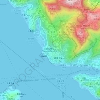
Name: Shui Choi Tin Village topographic map, elevation, terrain.
Average elevation: 94 m
Minimum elevation: -3 m
Maximum elevation: 507 m
Other topographic maps
Click on a map to view its topography, its elevation and its terrain.
Victoria Peak
China > Hong Kong > Hong Kong Island
Victoria Peak, Hong Kong Island, Hong Kong, 000000, China
Average elevation: 209 m
Hong Kong Island
China > Hong Kong > Hong Kong Island
Hong Kong Island, Southern District, Hong Kong, 852, China
Average elevation: 36 m
Eastern District
China > Hong Kong > Hong Kong Island
Eastern District, Hong Kong Island, Hong Kong, China
Average elevation: 84 m