
Thank you for supporting this site ❤️
Make a donation
Make a donation
Fenghuang County topographic map
Click on the map to display elevation.
Thank you for supporting this site ❤️
Make a donation
Make a donation
About this map
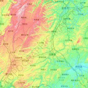
Name: Fenghuang County topographic map, elevation, terrain.
Location: Fenghuang County, Xiangxi, Hunan, 416200, China (27.72252 109.29499 28.31866 109.80107)
Average elevation: 497 m
Minimum elevation: 138 m
Maximum elevation: 1,222 m
Thank you for supporting this site ❤️
Make a donation
Make a donation
Other topographic maps
Click on a map to view its topography, its elevation and its terrain.