
Thank you for supporting this site ❤️
Make a donation
Make a donation
Mudanjiang topographic map
Click on the map to display elevation.
Thank you for supporting this site ❤️
Make a donation
Make a donation
Mudanjiang
It also borders Russia's Primorsky Krai to the east. The average elevation in the prefecture is 230 meters (755 ft), with the terrain primarily consisting of mountains and hills. The east of the prefecture begins to ascend to the Changbai Mountains, while the central parts belong to the Hegu Basin. The lowest part of the prefecture is Suifenhe City, bordering Russia, at a minimum elevation of 86.5 meters (283.8 ft), while the highest point is Zhangguangcai mountain, at 1,686.9 meters (5,534 ft).
Thank you for supporting this site ❤️
Make a donation
Make a donation
About this map
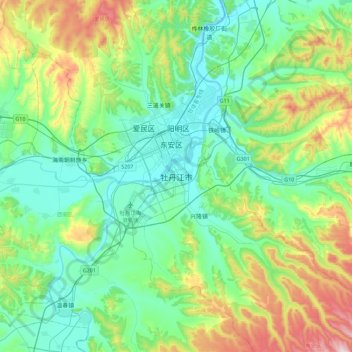
Name: Mudanjiang topographic map, elevation, terrain.
Average elevation: 361 m
Minimum elevation: 218 m
Maximum elevation: 787 m
Thank you for supporting this site ❤️
Make a donation
Make a donation
Other topographic maps
Click on a map to view its topography, its elevation and its terrain.