Geolocate

Huainan topographic map

Interactive map

Click on the map to display elevation.

About this map

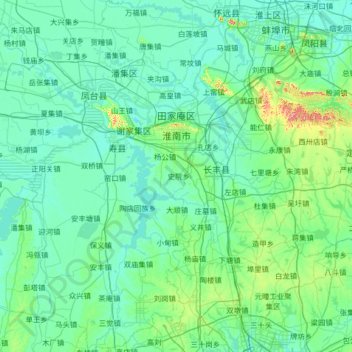
Name: Huainan topographic map, elevation, terrain.

Location: Huainan, Anhui, 202033, China (31.90218 116.35266 33.00731 117.20938)

Average elevation: 40 m

Minimum elevation: 12 m

Maximum elevation: 332 m

Other topographic maps

Click on a map to view its topography, its elevation and its terrain.

汤河

China > Anhui > Chaohu City

汤河, Bantang, Chaohu City, Hefei, Anhui, 238000, China

Average elevation: 52 m

Longgan Lake

China > Anhui > Susong County

Longgan Lake, Susong County, Anqing City, Anhui, China

Average elevation: 14 m

Huangshan City

China > Anhui > Huangshan City

Huangshan City, Anhui, China

Average elevation: 356 m

Hefei

China > Anhui

Hefei, Anhui, China

Average elevation: 75 m