
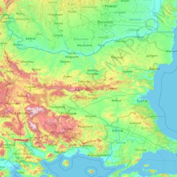
Bulgaria topographic map
Interactive map
Click on the map to display elevation.
About this map
Name: Bulgaria topographic map, elevation, terrain.
Location: Bulgaria (41.23537 22.35715 44.21554 28.88754)
Average elevation: 300 m
Minimum elevation: -3 m
Maximum elevation: 2,750 m
Bulgaria occupies a portion of the eastern Balkan peninsula, bordering five countries—Greece and Turkey to the south, Macedonia and Serbia to the west, and Romania to the north. The land borders have a total length of 1,808 kilometres (1,123 mi), and the coastline has a length of 354 kilometres (220 mi). Its total area of 110,994 square kilometres (42,855 sq mi) ranks it as the world's 105th-largest country. Bulgaria's geographic coordinates are 43° N 25° E. The most notable topographical features are the Danubian Plain, the Balkan Mountains, the Thracian Plain, and the Rila-Rhodope massif. The southern edge of the Danubian Plain slopes upward into the foothills of the Balkans, while the Danube defines the border with Romania. The Thracian Plain is roughly triangular, beginning southeast of Sofia and broadening as it reaches the Black Sea coast.
Other topographic maps
Click on a map to view its topography, its elevation and its terrain.
Philippines
Philippines
Average elevation: 33 m
Cebu City
Philippines > Cebu > Cebu City
Cebu City, Cebu, Central Visayas, 6000, Philippines
Average elevation: 140 m
Baguio
Baguio, Cordillera Administrative Region, 2600, Philippines
Average elevation: 1,371 m
Zamboanga City
Philippines > Zamboanga Peninsula > Zamboanga City
Zamboanga City, Zamboanga Peninsula, 7000, Philippines
Average elevation: 83 m
Rizal
Philippines > Quirino > Rizal
Rizal, Quirino, Cagayan Valley, Philippines
Average elevation: 130 m
Mt. Fuji
Japan > Sunto County > Oyama
Mt. Fuji, Oyama, Sunto County, Shizuoka Prefecture, Chubu Region, Japan
Average elevation: 3,261 m
Islands District
Islands District, New Territories, Hong Kong, China
Average elevation: 36 m
Münchweier
Germany > Baden-Württemberg > Ortenaukreis > Ettenheim
Münchweier, Ettenheim, Verwaltungsgemeinschaft Ettenheim, Ortenaukreis, Baden-Württemberg, 77955, Germany
Average elevation: 279 m
Socorro
Philippines > Negros Occidental > San Carlos > Punao
Socorro, Punao, San Carlos, Negros Occidental, Western Visayas, 6127, Philippines
Average elevation: 36 m
Suffolk County
Suffolk County, New York, United States
Average elevation: 34 m
Pasay
Pasay, Southern Manila District, Metro Manila, 1300, Philippines
Average elevation: 14 m
Quezon City
Quezon City, Eastern Manila District, Metro Manila, Philippines
Average elevation: 57 m
Woodbourne
United States > Pennsylvania > Bucks County > Middletown Township
Woodbourne, Middletown Township, Bucks County, Pennsylvania, 19047, United States
Average elevation: 48 m
Sorsogon City
Sorsogon City, Sorsogon, Bicol Region, 4700, Philippines
Average elevation: 89 m
Mount Fuji
United States > Wisconsin > Dunn County
Mount Fuji, Town of Colfax, Dunn County, Wisconsin, United States
Average elevation: 313 m
Red Bull Ring
Red Bull Ring, Spielberg, Murtal, Styria, 824, Austria
Average elevation: 755 m
San Jose
Philippines > Pangasinan > Labrador
San Jose, Labrador, Pangasinan, Ilocos Region, 2402, Philippines
Average elevation: 42 m
Ormoc
Philippines > Leyte > Ormoc
Ormoc, Leyte 4th District, Leyte, Eastern Visayas, 6541, Philippines
Average elevation: 204 m
San Fernando
San Fernando, Pampanga, Central Luzon, 2000, Philippines
Average elevation: 24 m
Boise
United States of America > Idaho > Boise
Boise, Ada County, Idaho, 83702, United States of America
Average elevation: 1,040 m
Johnstown
United States > Pennsylvania > Cambria County
Johnstown, Cambria County, Pennsylvania, United States
Average elevation: 469 m
Tuguegarao
Tuguegarao, Cagayan, Cagayan Valley, 3500, Philippines
Average elevation: 49 m
Paguludan-Salindeg
Philippines > Ilocos Norte > Currimao
Paguludan-Salindeg, Currimao, Ilocos Norte, Ilocos Region, 2902, Philippines
Average elevation: 5 m
Villa Conzoilo
Philippines > Leyte > Jaro
Villa Conzoilo, Jaro, 2nd District, Leyte, Eastern Visayas, 6527, Philippines
Average elevation: 410 m
Alaminos
Alaminos, Guadalajara, Castile-La Mancha, Spain
Average elevation: 1,049 m
Batangas City
Batangas City, Batangas, Calabarzon, 4200, Philippines
Average elevation: 65 m
Cornwells Heights
United States > Pennsylvania > Bucks County > Bensalem Township
Cornwells Heights, Bensalem Township, Bucks County, Pennsylvania, 19154, United States
Average elevation: 16 m
Dasmarinas
Philippines > Cavite > Dasmarinas > Buhi
Dasmarinas, Cavite, Calabarzon, 4114, Philippines
Average elevation: 114 m
San Fernando
San Fernando, La Union, Ilocos Region, 2500, Philippines
Average elevation: 81 m
Santa Rosa
Philippines > Laguna > Santa Rosa
Santa Rosa, Laguna, Calabarzon, 4026, Philippines
Average elevation: 65 m
Cabanatuan
Cabanatuan, Nueva Ecija, Central Luzon, 3100, Philippines
Average elevation: 47 m