Geolocate

La Union topographic map

Click on the map to display elevation.

La Union

Topography

Wikipedia (CC-BY-SA 3.0)

About this map

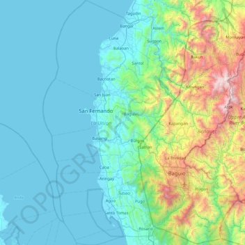
Name: La Union topographic map, elevation, terrain.

Location: La Union, Ilocos Region, Philippines (16.17666 120.13709 17.00335 120.58514)

Average elevation: 442 m

Minimum elevation: -1 m

Maximum elevation: 2,675 m

Other topographic maps

Click on a map to view its topography, its elevation and its terrain.

Quezon City

Philippines

Founded as a pueblo by Saint Pedro Bautista in 1590, San Francisco del Monte may be considered Quezon City's oldest district. The original land area of the old town of San Francisco del Monte was approximately2.5 square kilometres (1.0 sq mi) and covered parts of what is currently known as Project 7 and 8 and…

Average elevation: 57 m

Cebu City

Philippines > Cebu > Cebu City

Average elevation: 140 m

San Vicente

Philippines > Camarines Norte

Average elevation: 52 m

Santa Rosa

Philippines > Laguna > Santa Rosa

Average elevation: 65 m

Baguio

Philippines

In 1903, Filipinos, Japanese and Chinese workers were hired to build Kennon Road, the first road directly connecting Baguio with the lowlands of La Union and Pangasinan. Before this, the only road to Benguet was Naguilian Road, and it was largely a horse trail at higher elevations. Camp John Hay was…

Average elevation: 881 m

San Mariano

Philippines > Isabela

Average elevation: 98 m

Cabuyao

Philippines > Laguna

Average elevation: 93 m

Antipolo

Philippines > Rizal

Its higher elevation than that of Metro Manila affords it a scenic view of the metropolis, especially at night. Its locally grown mangoes and cashews are popular among tourists, as well as suman – a local delicacy made out of glutinous rice. The Hinulugang Taktak National Park, which was once a popular…

Average elevation: 125 m

Naguilian

Philippines > La Union

The approximate elevation of the municipality is 165 meters above sea level. It has the ninth highest approximate average elevation among the twenty (20) towns of the province. The portion with the highest elevation is 544 meters above sea level while the lowest is 10 meters. The slopes range from 2–7% in…

Average elevation: 85 m

Macabebe

Philippines > Pampanga

Average elevation: 3 m

Lake Sebu

Philippines > South Cotabato

The placid lake of Lake Sebu can be found in Allah Valley near the municipality of Surallah, South Cotabato. Surrounded by rolling hills and mountains covered with thick rain forest, the lake has an area of 361.124 hectares (892.36 acres), with an elevation of approximately 1,000 metres (3,300 ft).

Average elevation: 750 m

Rizal

Philippines

Average elevation: 95 m

Mandaue

Philippines

It is one of the two (the other one being the municipality of Consolacion) local government units located within the mainland Metro Cebu where the elevation of land is less than 100 m (330 ft).

Average elevation: 109 m

Tagaytay

Philippines > Cavite

The southern and eastern portions of Tagaytay are covered by hills and mountains which is generally forests, pine trees and open grasslands. The city lies along Tagaytay Ridge, a ridge stretching about 32 kilometres (20 mi) from Mount Batulao in the west to Mount Sungay in the east with elevations averaging…

Average elevation: 229 m

San Jose Mesulo

Philippines > Pampanga > Arayat

Average elevation: 9 m

Mintal

Philippines > Davao City

Average elevation: 130 m

Medellin

Philippines > Cebu

Average elevation: 11 m

Tanay

Philippines > Rizal

Average elevation: 32 m

Tuba

Philippines > Benguet

Tuba's topography is generally characterized by irregular rugged terrain and steep slopes with several mountain peaks rising from the table land itself. Mount Santo Tomas, the highest peak in the municipality soars to 2,252 metres (7,388 ft) above sea level.

Average elevation: 1,242 m

San Fernando

Philippines > Pampanga

Average elevation: 24 m

Davao Gulf

Philippines

Average elevation: 0 m

Passi

Philippines > Iloilo

Average elevation: 81 m

Cabucgayan

Philippines > Biliran

Average elevation: 104 m

Bohol

Philippines

Average elevation: 116 m

Cebu

Philippines

Average elevation: 89 m

Sibalom

Philippines > Antique

Average elevation: 24 m

Lemery

Philippines > Iloilo

Average elevation: 120 m

Cabatuan

Philippines > Iloilo

Average elevation: 74 m

Pantabangan

Philippines > Nueva Ecija

Average elevation: 258 m

Calabanga

Philippines > Camarines Sur

The topographic landscape of the municipality could be characterized as generally flat with a slope 0-3%, gently sloping (3-8%) towards the direction of the eastern portion and finally rolling up to higher steeps towards the direction of the south-eastern part going to Mt. Isarog. The 0-3% slope is a broad…

Average elevation: 11 m

Marawi

Philippines > Lanao del Sur

Marawi is located upon the shores of Lake Lanao.[6] It is primarily inhabited by the Maranao people. The city is also called the "summer capital of the south" due to its higher elevation and cooler climate,[7] a nickname it shares with Malaybalay.[8][better source needed]

Average elevation: 707 m

Pantukan

Philippines > Davao de Oro

Average elevation: 13 m

Lapu-Lapu

Philippines

Average elevation: 93 m

Bolo Creek

Philippines > Benguet > La Trinidad > Cruz > Cabanao

Average elevation: 1,313 m

Tarlac

Philippines

Average elevation: 109 m

Camarines Sur

Philippines

Average elevation: 56 m

Tacurong

Philippines > Sultan Kudarat

Average elevation: 52 m

Talisay

Philippines > Negros Occidental > Talisay

Average elevation: 53 m

Lucban

Philippines

Average elevation: 504 m

Padre Garcia

Philippines > Batangas > Padre Garcia

Average elevation: 172 m

Langogan

Philippines > Puerto Princesa

Average elevation: 132 m

Pago

Philippines > Leyte > Tanauan

Average elevation: 6 m

Napnapan

Philippines > Davao de Oro

Average elevation: 94 m

Galimuyod

Philippines > Ilocos Sur

Average elevation: 36 m

San Miguel

Philippines > Bulacan

Average elevation: 22 m

Daraga

Philippines > Albay

67.3% of the total municipal land area has a predominantly low elevation of up to 100 metres (330 ft). The surface terrain is generally characterized by combination of level to nearly level areas, gentle to undulating areas and undulating to rolling areas.

Average elevation: 76 m

Bacolod

Philippines

Bacólod (English: Bacolod), is derived from bakólod (Old Spelling: bacólod), the Old Hiligaynon (Old Ilonggo) (Old Spelling: Ylongo and Ilongo) word for a "hill, turtle, mound, rise, hillock, down, any small eminence or elevation", since the resettlement was founded on a stony, hilly area, now the barangay…

Average elevation: 49 m

Tabaan Sur

Philippines > Benguet

Average elevation: 676 m

Nueva Era

Philippines > Ilocos Norte

Average elevation: 200 m

Kibungan

Philippines > Benguet

The municipality is within a cool highland mountainous zone with elevations at more than 2,500 metres (8,200 ft) above sea level. During its coolest months of December to January, Barangay Madaymen experiences chilling temperature of 0 °C (32 °F), causing the famous Frost of Madaymen.

Average elevation: 1,249 m

San Juan

Philippines

"San Juan" is a contraction of the city's traditional name of "San Juan del Monte" (lit. 'Saint John of the Mountain'). As with numerous other places in the Philippines, the name combines a patron saint and a toponym; in this case Saint John the Baptist with the locale's hilly terrain and relatively higher…

Average elevation: 35 m

Tadian

Philippines > Mountain Province

Average elevation: 1,155 m

Talipao

Philippines > Sulu

Average elevation: 138 m

Batuan

Philippines > Bohol

Average elevation: 316 m

Taguig

Philippines

Average elevation: 39 m

Nueva Vizcaya

Philippines

Average elevation: 107 m

Marihatag

Philippines > Surigao del Sur

Average elevation: 12 m

Valenzuela

Philippines

The highest elevation point is 38 meters (125 ft) above sea level. Having a surface gradient of 0.55% and a gentle slope, hilly landscape is located in the industrial section of the city in Canumay. The average elevation point is 2 meters (6.6 ft) above sea level.

Average elevation: 24 m

General Tinio

Philippines > Nueva Ecija

Farming is the livelihood of majority of the residents. Even though located at the foot of the Sierra Madre Mountain Ridges, the topography is generally plain ideal to agricultural products such as palay and vegetables. A number of poultry broiler contract growers are located in the municipality. Other…

Average elevation: 54 m

Sablan

Philippines > Benguet

Average elevation: 501 m

Ozamiz

Philippines > Misamis Occidental

Average elevation: 161 m

Mandaluyong

Philippines

Another claims that the Spaniards named the place based on the report of a navigator named Acapulco, who saw the rolling hills frequently being lashed at by daluyong (“big waves from the sea”). This seems to confirm traditional pre-Hispanic stories that giant waves from the sea would meet the adjoining…

Average elevation: 33 m

Butuan

Philippines

Average elevation: 115 m

Marikina

Philippines

Average elevation: 80 m

Patag Island

Philippines

Average elevation: 0 m

Kota Island

Philippines

Average elevation: 0 m

Lankiam Cay

Philippines

Average elevation: 0 m

Iriga

Philippines

Average elevation: 115 m

Maislap

Philippines > Rizal > Montalban

Average elevation: 82 m

Puting Bato

Philippines > Agusan del Norte > Cabadbaran

Average elevation: 231 m

Mount Halcon

Philippines > Oriental Mindoro

Mount Halcon (Filipino: Bundok Halcon) and (Spanish: Monte Halcón) is the highest mountain in Mindoro. According to the new data released by Oriental Mindoro peakvisor as of 2022, it has an elevation of 2,616 metres (8,583 ft) above sea level, higher than the previous estimates of 2,586 m (8,484 ft) although…

Average elevation: 2,121 m

Lawak Island

Philippines

Average elevation: 0 m

Libungan

Philippines > North Cotabato

Average elevation: 39 m

Surigao del Sur

Philippines

Average elevation: 274 m

Candaba

Philippines

Average elevation: 6 m

Davao City

Philippines

Average elevation: 65 m

Kinatihan II

Philippines

Average elevation: 22 m

Ibabang Bukal

Philippines

Average elevation: 254 m

Cabatang

Philippines

Average elevation: 335 m

Carilucud

Philippines > Cagayan

Average elevation: 39 m

Pinget

Philippines

Average elevation: 1,430 m

Caloocan

Philippines

Average elevation: 81 m

Aurora Hill North Central

Philippines

Average elevation: 1,479 m

Besigan

Philippines

Average elevation: 584 m

Talomo River

Philippines

Average elevation: 201 m

Asin

Philippines

Average elevation: 1,321 m

Catambungan

Philippines

Average elevation: 5 m

Tablas Strait

Philippines

Average elevation: 0 m

Kalikid Sur

Philippines > Nueva Ecija

Average elevation: 57 m

Buenavista

Philippines

Average elevation: 112 m

Poliwes

Philippines

Average elevation: 1,397 m

Teodora Alonzo

Philippines

Average elevation: 1,459 m

Manggahan

Philippines

Average elevation: 7 m

Bakakeng Norte

Philippines

Average elevation: 1,379 m

Kapatagan

Philippines > Davao del Sur > Digos

Average elevation: 1,081 m

New Carmen

Philippines

Average elevation: 98 m

Crossing Bayabas

Philippines

Average elevation: 22 m