
Make a donation
San Fernando topographic map
Click on the map to display elevation.
Make a donation
About this map
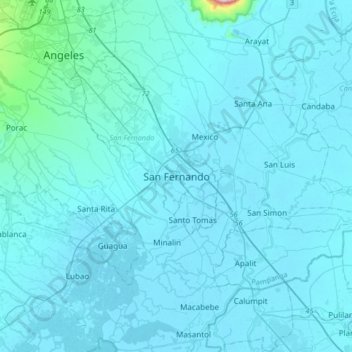
Name: San Fernando topographic map, elevation, terrain.
Location: San Fernando, Pampanga, Central Luzon, 2000, Philippines (14.86830 120.53380 15.18830 120.85380)
Average elevation: 24 m
Minimum elevation: -2 m
Maximum elevation: 655 m
Make a donation
Other topographic maps
Click on a map to view its topography, its elevation and its terrain.
Guagua
The climate and topographical features of the vast land of Guagua make it ideal for the growing of fruit trees and vegetables. Among the fruit trees most fitting to be planted are mangoes, guavas, santol, star apples, and bananas. For vegetables, sitao, upo, ampalaya, gabi and cucumber are the most commonly…
Average elevation: 9 m
Make a donation
Floridablanca
Floridablanca is located on the western part of Pampanga along the Zambales mountain ranges and is bounded by the municipalities of Porac on the north, Lubao on the south, Guagua on the east, and Dinalupihan, Bataan on the west. It is 40 kilometers (25 mi) from the city of San Fernando and 106 kilometers (66…
Average elevation: 35 m
Make a donation
Make a donation
Make a donation
Make a donation
Make a donation
Make a donation
Make a donation
Make a donation
Make a donation
Make a donation
Make a donation
Floridablanca
Floridablanca is located on the western part of Pampanga along the Zambales mountain ranges and is bounded by the municipalities of Porac on the north, Lubao on the south, Guagua on the east, and Dinalupihan, Bataan on the west. It is 40 kilometers (25 mi) from the city of San Fernando and 106 kilometers (66…
Average elevation: 35 m
Make a donation
Floridablanca
The town is at an elevation of 12 feet (3.7 m) above sea level. Floridablanca is north of Dinalupihan via Dinalupihan-Floridablanca Access Road at the Bataan-Pampanga boundary line.
Average elevation: 35 m
Make a donation
Make a donation
Make a donation
Floridablanca
The town is at an elevation of 12 feet (3.7 m) above sea level. Floridablanca is north of Dinalupihan via Dinalupihan-Floridablanca Access Road at the Bataan-Pampanga boundary line.
Average elevation: 35 m
Make a donation
Floridablanca
The town is at an elevation of 12 feet (3.7 m) above sea level. Floridablanca is north of Dinalupihan via Dinalupihan-Floridablanca Access Road at the Bataan-Pampanga boundary line.
Average elevation: 35 m
Make a donation
Floridablanca
The town is at an elevation of 12 feet (3.7 m) above sea level. Floridablanca is north of Dinalupihan via Dinalupihan-Floridablanca Access Road at the Bataan-Pampanga boundary line.
Average elevation: 35 m
Make a donation
Make a donation
Make a donation
Make a donation
Make a donation
Make a donation
Guagua
The climate and topographical features of the vast land of Guagua make it ideal for the growing of fruit trees and vegetables. Among the fruit trees most fitting to be planted are mangoes, guavas, santol, star apples, and bananas. For vegetables, sitao, upo, ampalaya, gabi and cucumber are the most commonly…
Average elevation: 9 m