
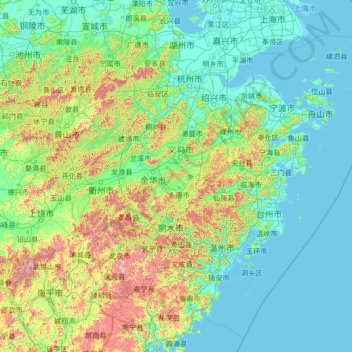
Zhejiang topographic map
Interactive map
Click on the map to display elevation.
About this map
Name: Zhejiang topographic map, elevation, terrain.
Location: Zhejiang, China (26.85910 118.02241 31.18258 123.39362)
Average elevation: 223 m
Minimum elevation: -2 m
Maximum elevation: 2,037 m
Zhejiang consists mostly of hills, which account for about 70% of its total area, with higher altitudes towards the south and the west. Zhejiang also has a longer coastline than any other mainland province of China. The Qiantang River runs through the province, from which it derives its name. Included in the province are three thousand islands, the most in China. The capital Hangzhou marks the end of the Grand Canal and lies on Hangzhou Bay on the north of Zhejiang, which separates Shanghai and Ningbo. The bay contains many small islands collectively called the Zhoushan Islands.
Other topographic maps
Click on a map to view its topography, its elevation and its terrain.
Double Island
China > Hong Kong > North District > Tung Wan
Double Island, Tung Wan, North District, New Territories, Hong Kong, China
Average elevation: 12 m
Lanting
China > Jiangxi > Hukou County > Junqiao
Lanting, Junqiao, Hukou County, Jiangxi, China
Average elevation: 23 m
Labo River
China > Sichuan > Litang County > Nabo > Zhazha
Labo River, Zhazha, Nabo, Litang County, Kardze, Sichuan, China
Average elevation: 3,708 m
Fenghuang Mountain
China > Zhejiang > Hangzhou City
Fenghuang Mountain, Hangzhou City, Zhejiang, 310002, China
Average elevation: 44 m
Fenghuang County
Fenghuang County, Xiangxi, Hunan, 416200, China
Average elevation: 497 m
Bao'an District
Bao'an District, Shenzhen, Guangdong Province, 518100, China
Average elevation: 36 m
Kashgar Prefecture
China > Xinjiang > Kashgar City
Kashgar Prefecture, Kashgar City, Kachgar, Xinjiang, 844000, China
Average elevation: 2,275 m
Lian River
China > Jiangxi > Yudu County
Lian River, Yudu County, Ganzhou, Jiangxi, China
Average elevation: 243 m
Golog Tibetan Autonomous Prefecture
China > Qinghai > Gadê County
Golog Tibetan Autonomous Prefecture, Gadê County, Golog, Qinghai, China
Average elevation: 4,340 m
Heihe
China > Heilongjiang > 幸福乡
Heihe, 幸福乡, Aihui District, Heihe City, Heilongjiang, 164300, China
Average elevation: 174 m
Mudanjiang
Mudanjiang, Revitalize the streets, Dong'an District, Mudanjiang City, Heilongjiang, 157000, China
Average elevation: 361 m
Shui Choi Tin Village
China > Hong Kong > Hong Kong Island
Shui Choi Tin Village, Southern District, Hong Kong Island, Hong Kong, China
Average elevation: 94 m
Baotou City
Baotou City, Inner Mongolia, 014000, China
Average elevation: 1,318 m
Chengguan District
Chengguan District, Lhasa, Tibet, 850000, China
Average elevation: 4,325 m